Most people today do not consider the significance of early Honolulu historic buildings that are all built from blocks of limestone karst (ancient reef,) that subterrainian karst waterways and springs still exist and the sacred 1825 Pohukaina royal burial place was inside a karst cave located today on the grounds of royal palace.

These very significant features in Honolulu actually originated in earlier ancient native Hawaiian customs and beliefs from Ewa Honouliuli. The native Hawaiian community of Honouliuli was the original cultural and political capital of Oahu (not Honolulu)

SB1417 - Hawaiian archaeological, historic, and cultural sites shall be preserved and protected in Kalaeloa. Endangered species of flora and fauna and significant military facilities shall be preserved in Kalaeloa. (However, HCDA Kalaeloa administrator has rejected this!)
HCDA administration says this will not be in their $500,000 Kalaeloa Master Plan because of big developer objections.
Above quoted in Tuggles Navy BRAC reports and other subsequent Ewa Plain project reports
Ancient Kanehili (MCAS Ewa Field) actually has many still surviving sites of pre-western contact native Ewa Hawaiian culture yet HCDA Master Plan will wipe these out
Karst features and landforms are found all over the US mainland, Europe and Asia. Some are massive scale world heritage sites. Yet on Oahu developers destroy them. There is little understanding and few protections for these remnants of Ewa native Hawaiian culture.
https://en.wikipedia.org/wiki/Karst
Photo Gallery (U.S. National Park Service) (nps.gov)
Where did the Polynesians come from who settled Ewa Honouliuli?
https://en.wikipedia.org/wiki/Taputapuatea
https://www.polynesiaparadise.com/french-polynesia/raiatea-island/taputapuatea-marae/
Na ‘Ohana Holo Moana: Gathering of Eight Voyaging Canoes at Taputapuatea, March 1995
https://archive.hokulea.com/holokai/1995/taputapuatea_events.html
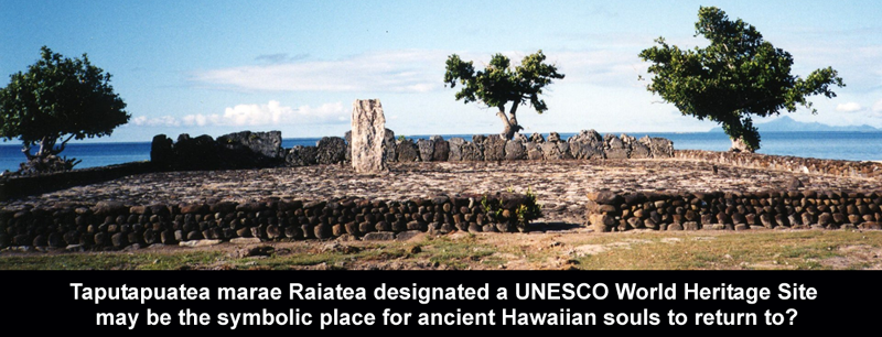
Taputapuatea: The Taputapuatea marae has been classified a UNESCO World Heritage Site
The commune was named after a large marae complex which was the religious center of eastern Polynesia for roughly 1000 years.The archaeological site of Taputapuatea marae is still today the most famous landmark of Raiatea, and it was inscribed on the UNESCO World Heritage List in 2017
This marae holds the Te-Papa-tea-o-Ruea, or white investiture stone, brought by the god Hiro to found the chiefdoms or ari'i on Raiatea. Hauviri was the welcoming marae which received visitors as they disembarked from their canoes. This site was a meeting place and sacrificial site for travellers from all over the Pacific. This marae—the most sacred communal place to ancient Tahitians—consists of three large stone platforms as well as shrines and expressive tikis.
History of Oceanography and Polynesian voyaging
PowerPoint Presentation (hawaii.edu)
Provisions for Polynesian Voyages - Tommy Holmes
https://archive.hokulea.com/ike/canoe_living/holmes_provisioning.html
Polynesian Navigation & Settlement of the Pacific
Polynesian Navigation & Settlement of the Pacific - World History Encyclopedia

KUMULIPO
In the Kumulipo, the Hawaiian creation chant, the coral polyp or ko'a was one of the first living organisms created along with Kumulipo and Pō'ele, the first man and woman. The ko'a was then followed by the creation of urchins, sea cucumbers, sea stars, and so forth.
The births in each age include:
In the first wā, the sea urchins and limu (seaweed) were born. The limu was connected through its name to the land ferns. Some of these limu and fern pairs include: ʻEkaha and ʻEkahakaha, Limu ʻAʻalaʻula and ʻalaʻalawainui mint, Limu Manauea and Kalo Maunauea upland taro, Limu Kala and ʻakala berry. These plants were born to protect their sea cousins. In the second wā, 73 types of fish. Some deep sea fish include Naiʻa (porpoise) and the Mano (shark). Also reef fish, including Moi and Weke. Certain plants that have similar names are related to these fish and are born as protectors of the fish.
In the third wā, 52 types of flying creatures, which include birds of the sea such as ʻIwa (frigate or man-of-war bird), the Lupe, and the Noio (Hawaiian noddy tern). These sea birds have land relatives, such as Io (hawk), Nene (goose), and Pueo (owl). In this wā, insects were also born, such as Peʻelua (caterpillar) and the Pulelehua (butterfly).
Polynesian creation myths often depict elements of the supernatural or celestial when coming up with legends about how the world came into being. Māori and Tongans share Polynesian creation myths that are similar to Hawai’i usually involving a period of darkness before the light comes to the world.
In the Kumulipo the world was created over a cosmic night. This is not just one night, but many nights over time. The ancient Hawaiian kahuna and priests of the Hawaiian religion would recite the Kumulipo during the Makahiki season, honoring the god Lono. In 1779, Captain James Cook arrived in Kealakekua Bay on the island of Hawaiʻi during the season and was greeted by the Hawaiians reciting the Kumulipo.
The Kumulipo is the sacred creation chant of Hawaiian ali’i (ruling chiefs.) Composed and transmitted entirely in the oral tradition, its 2000 lines provide an extended genealogy proving the family's divine origin and tracing the family history from the beginning of the world. The Kumulipo was first recorded by Westerners in the 18th century. The Kumulipo, in Hawaiian, in Liliʻuokalani's English translation and in English translations, Bastian and Beckwith's - appear in Beckwith's 1951 book The Kumulipo.
https://en.wikipedia.org/wiki/Kumulipo
https://www.sacred-texts.com/pac/lku/index.htm
https://www.thecollector.com/polynesian-creation-myths/
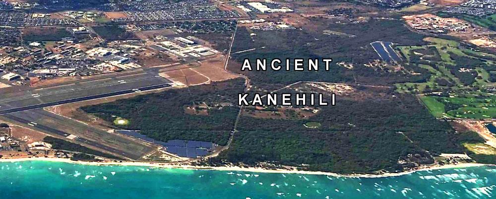
Ancient Kanehili – the central area still exists
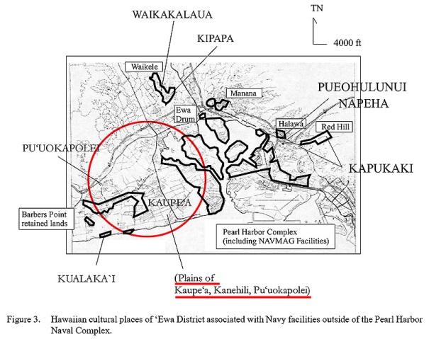
Ewa Honouliuli/Pu‘uloa. An open kula land (sloping land between mountain and sea,) noted in recorded oral and published traditions for its association with Kaupe‘a, a place of wandering spirits. An uninhabited plain with wiliwili (Erythrina sandwicensis) trees and associated with Kanehili (makai of Kaupe’a) and Leiolono (a spirit leaping place atop Aliamanu.) Cited in traditions, oral history interviews and in the chants of Hi‘iaka-i-ka-poli-o-Pele.
Culturally, Kanehili and the Ewa Plain where Honouliuli was the royal and political capital, was greatly influenced by the Polynesian culture from Tahiti and Marquesas Islands. Early arriving canoe landings were along the Ewa shoreline – Kualaka’i, One’ula and Pu’uloa.

Kanehili is an ancient place name also closely associated with Pu'uokapolei, Kaupe'a and the Kualaka'i shore line and village. Kanehili may literally mean “Kane strikes,” however hili means to braid as a lei. “Kane”refers to a male such as a husband, brother, etc. “Kāne”also has another meaning. Kāne, in Hawaiian mythology, is one of the four major gods. Kāne is considered the highest of the three major Hawaiian deities, along with Kū and Lono, representing the god of procreation and as the ancestor of chiefs and commoners. Kāne is the creator and gives life associated with dawn, sun and sky. No human sacrifice or laborious ritual was needed in the worship of Kāne. In the Kumuhonua legend, he created Earth, bestowed upon it sea creatures, animals, plants, as well as created man and woman.
https://www.kumupono.com/wp-content/uploads/2021/03/1chusohuu_113806.pdf
Kanehili was known for many things, including birds and bird feathers
The bird feather lei is one of the oldest and most traditional art forms in Hawaiian culture. It symbolizes the spirit of Hawaii and is often a sign of respect, dignity, and strength. Feather lei were once made for high-ranking Hawaiian ali'i (chiefs).
The birds most associated with Ahu’ula – royal cape are the O’o and Mamo. They used to be plentiful in Kanehili however over collection for feather capes decimated their populations.
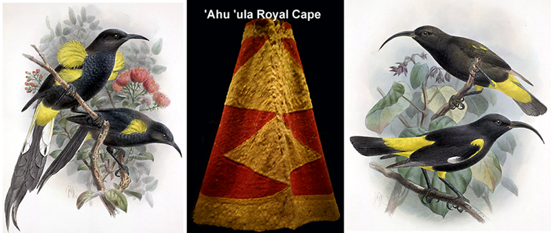
Male and female ‘O‘ō (Moho nobilis) perching on ‘ōhi‘a tree; believed to be extinct by 1902.
Male and female Mamo (Drepanis pacifica); believed to be extinct by 1898.
There were later attempts at preservation by catching birds using nets, plucking their yellow feathers, and then releasing them. Gathering feathers was a native profession, using nets and sticky sap that could be placed on likely roosts. When a bird landed and got stuck, the bird catcher could pluck the desired feathers, clean the bird's claws, then release them to grow more feathers, hoping they would return again for future feather harvests.
https://www.oohawaii.com/the-hawaiian-oo-bird/
This research focuses on the historical demise of Hawaiian avifauna due to hunting by ancient Polynesians. Numerous documents, published since the early 1800s, were scrutinized and evaluated; these provided information on bird hunting and traditional Hawaiian practices. Hawaiians used birds as sources of feathers and food. Feathers were important symbols of power for Polynesians; in Hawai’i, feathers were more highly prized than other types of property. Feathers used for crafts were obtained from at least 24 bird species, however, the golden feathers of ‘ō‘ō and mamo birds made them primary targets for bird hunters; both birds became extinct by the late 1800s. Feathers were utilized for many items, including ‘ahu‘ula [cloaks], mahiole [war helmets], and kāhili [standards].
Feathers were utilized to manufacture a wide assortment of items, which included ‘ahu and ‘ahu‘ula [feathered capes and long cloaks], kīpuka [short shoulder capes], mahiole [feathered war helmets], kāhili [feather standards], lei hulu manu [feathered garlands], kā‘ei [feathered belts or sashes], feathered malo [loincloth or girdle] worn over the waist and shoulder during the investiture of kings, and—for female chiefs—pā‘ū hulu manu [feathered skirts for state occassions], pāpale [caps, or hats], basketry, and images, as well as ‘for the decoration of the Makahiki-idol’
https://www.mdpi.com/2673-7086/1/3/12
After nearly 1000 years as a developing Hawaiian cultural landscape based upon oral histories the western world arrived in Ewa Honouliuli in 1825. Specifically at the royal and political capital of Honouliuli located inside Puuloa at what is known today as West Loch. The Royal Navy survey ship HMS Blonde arrived with royal bodies from England as well as a surveyor, artist and botanist. Perhaps the most important event for the history of the Ewa Plain was the survey mapping on the ancient Hawaiian trails and related geographic features. These were extremely important clues to link place names and how Hawaiians viewed their Ewa Plain landscape.

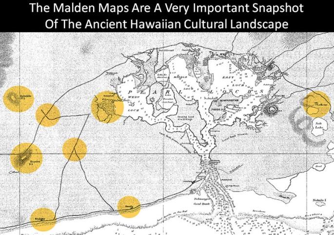
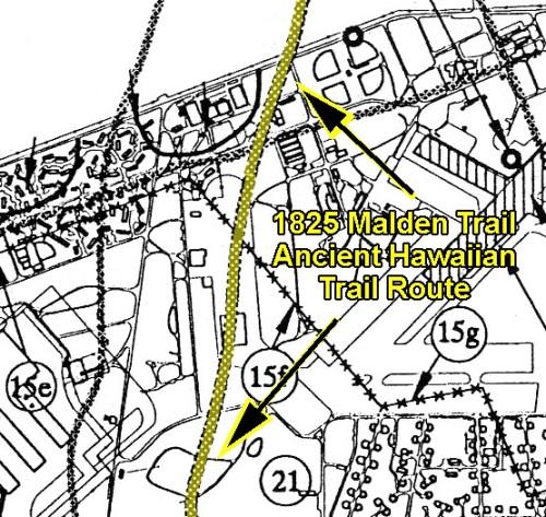
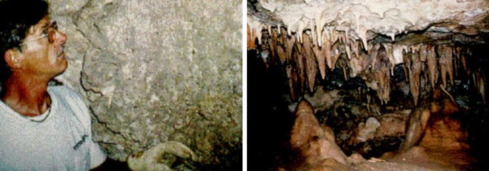
Above, 1825 Malden maps documented the cultural and historical sites of the Ewa Plain. Navy BRAC archeologists David Tuggle & Myra Tomonari-Tuggle (1997-99) were able to interpret observable archeological features and determine where the 1825 Malden trails ran through the former NAS Barbers Point and MCAS Ewa Field (today called Kalaeloa for development purposes.) The remaining Hawaiian habitation sites were near caves and sinkholes which provided a source of freshwater, agricultural plots and even for iwi burials. For early Hawaiians karst features were extremely important and they knew the differences between sinkhole and cave types (not all sinkholes and caves are the same.)

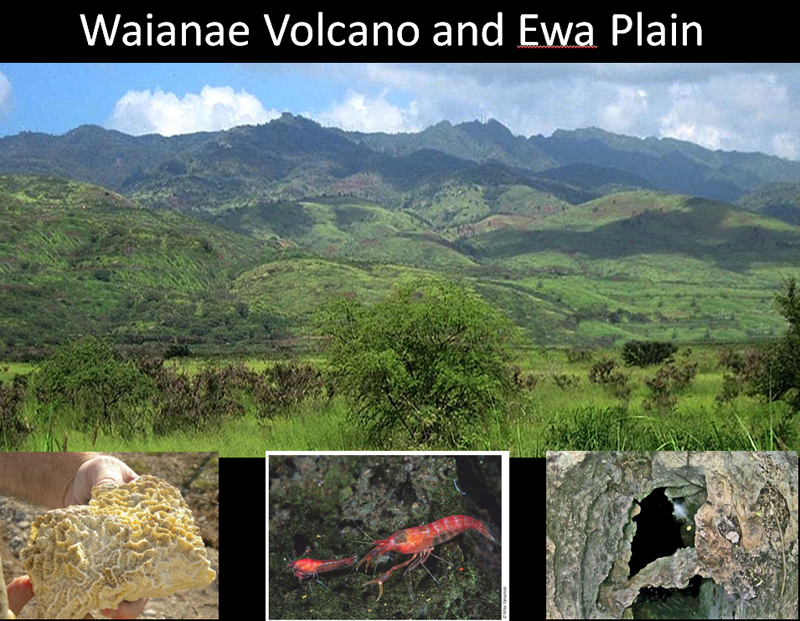
The Ewa Plain has the most unique cultural karst landscape anywhere in the Hawaiian Islands yet most people still don’t know this or how it is an entire mountain to sea ecological system which is being continuously destroyed by Ewa developers. Kanehili is the last area not yet destroyed.


1925 air photos show Ewa Plain Kanehili freshwater karst ponds. Close ups reveal even more.
US Fish & Wildlife Demonstrates How Ewa Plain Karst Can Be Restored
https://ewa-hawaii-karst.blogspot.com/2014/12/us-fish-wildlife-ewa-preserve.html

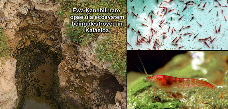
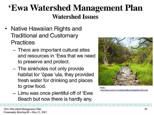
The rare Ewa karst cave subterranean waterways Holocaridinea rubra- Opae ula are a very endangered important native species in their original Ewa habitats. Popular worldwide as unique pets, in their original karst environment they are in real danger of being killed off by Ewa developers. A major concern is that the shrimp’s sole habitat is shrinking, with over 90% of Hawaii’s anchialine pools having disappeared due to development, and this species of shrimp is disappearing along with them.
Anchialine Pools A Window to a Hidden World HD
https://www.youtube.com/watch?v=IAhMOO2Ggh0
Disappearing native Hawaiian Opae Ula- Science Nation
https://www.youtube.com/watch?v=RKw8cQMQbhM

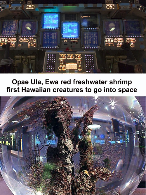
From Ewa karst caves to space travel, Opae ula can live for a decade in a totally enclosed sphere, they may provide important scientific clues for long distance space travel, alien life forms.
Halocaridina rubra, Hawaiian red shrimp
https://en.wikipedia.org/wiki/Halocaridina_rubra
https://www.shrimpscience.com/species/opae-ula-shrimp/
American Museum of Natural History
Exhibit of the Day: the ecosphere from our Hall of the Universe! Containing bacteria, algae, and tiny Ewa Holocaridinea rubra shrimp, this ecosphere was sealed in 1999 and hasn’t been opened since—it’s a self-sustaining habitat. No feeding is required, and there’s no overpopulation or pollution! How does it work? Algae make food from sunlight. Shrimp take oxygen from the water and exhale carbon dioxide; algae take in the carbon dioxide and give off oxygen! Microbes feed the shrimp—and in turn, the carbon dioxide-rich shrimp poop helps the algae and microbes!
Opae ula can be purchased in pet stores, however in their natural Ewa karst habitat they are becoming increasingly rare and killed off by developers. They are small red shrimp, rarely longer than 1.5 cm (0.6 in) in length, typically found in brackish water pools near the sea shore, sometimes in large numbers. Such pools are referred to as anchialine pools (from the Greek anchialos = near the sea). Halocaridina rubra is endemic to the Hawaiian islands, and are most commonly found in anchialine pools and in limestone karst pools and hypogeal habitats in limestone sinkholes and caves such as the Ewa Plain.
Recent popularity of ōpaeʻula as a low-maintenance pet in Hawaii and elsewhere has brought this otherwise obscure decapod crustacean into popular consciousness. A long-lived species, ōpaeʻula have been known to live for as long as 20 years in captivity. Sexes are difficult to distinguish, except when gravid females carry clusters of red/maroon eggs under their pleopods. Early larvae are planktonic filter-feeders. Stressed ōpaeʻula tend to hide, though if given plenty of places to hide they are more likely to venture into open spaces. Ōpaeʻula are social creatures and are rarely seen fighting, in fact when unstressed they often cluster together while eating or sunbathing. Shrimp in tanks can also be seen cleaning themselves or swimming slow laps.
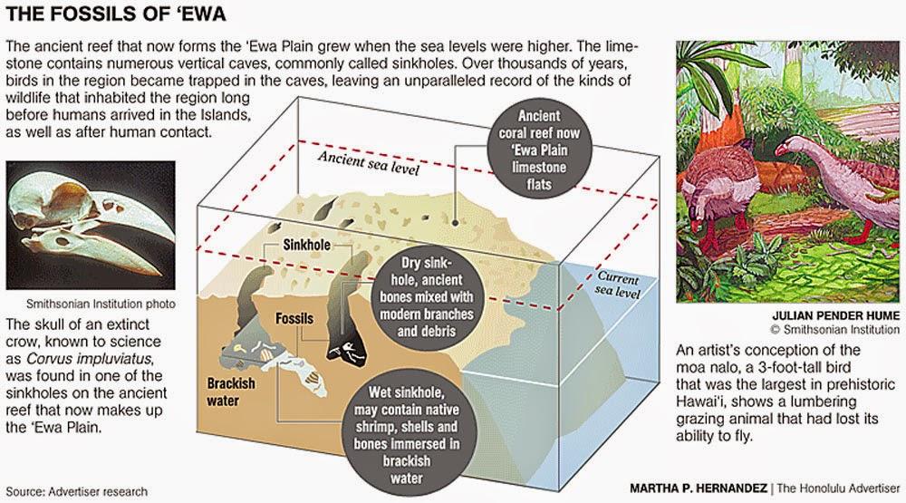
The bird bones were discovered while scientists were restoring tidal pools that were once part of the former Barbers Point Naval Station, now the Pearl Harbor National Wildlife Refuge-Kalaeloa Unit. Scientists have found remains of an extinct hawk—the first reported as a fossil on Oahu—a long-legged owl, Hawaiian sea eagle, petrel, two species of crow, Hawaiian finches, Hawaiian honeyeaters and the moa nalo—a flightless gooselike duck.


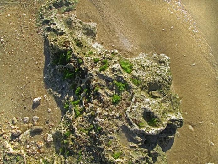
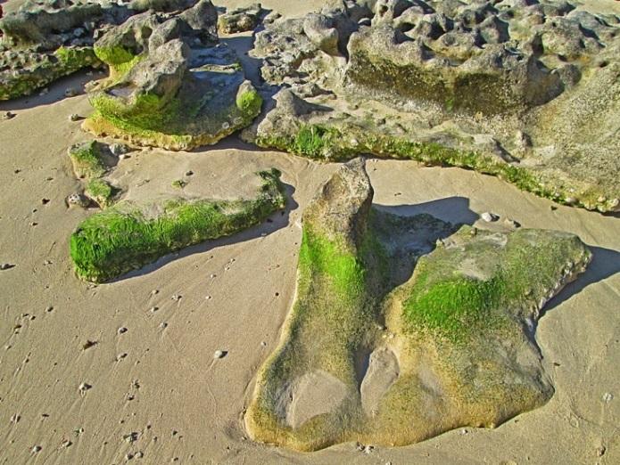
Karst limestone in the Ewa Plains has hundreds of springs, caves, sinkholes. Developers destroy them.

Ewa karst cave found by Roosevelt Avenue was later destroyed by DHHL developer
A Hawaiian made tool found on Hunt-Navy PV site was declared as not human made, destroyed.
The MCAS Ewa Field command history states that “ancient subterranean caverns” were found “large enough to house a freight car.” There are photos of a large D-8 bulldozer fallen into a large cave. Later NASBP development operations also report large bulldozers falling into Kanehili area caves.

There is no other place on Oahu or in Hawaii that is as culturally unique and significant as the ancient Kanehili waterway karst caves and ancient native Hawaiian trails
Honouliuli Ewa Limu Was the "House Of Limu" Because Of Ewa Plain Karst Spring Water


Haseko systematically wiped out native Hawaiian cultural sites linked to the Oneula trail. Now the HCDA Master Plan for Kalaeloa wants to wipe out remaining ancient Kanehili sites for condominiums.
Wickler, Stephen K. and Tuggle, H. David (1997). A Cultural Resource Inventory of Naval Air Station, Barbers Point, Oʻahu, Hawaiʻi; Part II: Phase II Inventory Survey of Selected Sites. International Archaeological Research Institute, Inc. Honolulu, HI. July 1997.

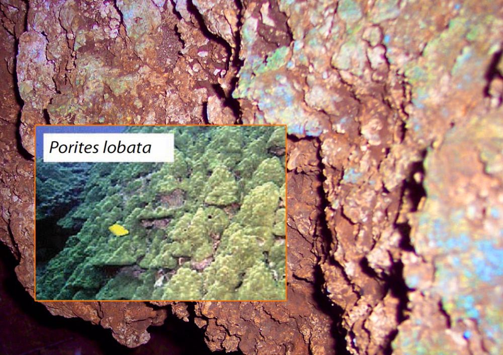
Coral reefs were important to the ancient Hawaiians for subsistence, culture, and survival.
According to the Hawaiian Creation Chant, the Kumulipo, the coral polyp was the first creature to emerge from the sea during creation. The early Hawaiians recognized that coral reefs were an essential building block of their existence and used coral in religious ceremonies to honor and care for ocean resources.
Ancient Hawaiians saw that from the ancient karst sprung thousands of freshwater springs, fostered an entire bountiful marine ecosystem, aerated fishponds and provided lush agricultural kalo fields.
Deep karst waterway channels flow underground through the entire Ewa Plain.
Hundreds of deep holes dug for Innergex solar tracking panels penetrates into the coralline deposits allowing surface contaminants, detergents, oils, into the subsurface water that feeds the limu and shoreline ecosystem which kills off the turtles, seals, reef fish, crustaceans and reduces the pelagic fisheries.
Where healthy edible limu (algae) is found is nearly always where fresh water enters into the sea, providing the necessary nutrients for regeneration. Shutting off or polluting this karst water system kills off the entire marine ecosystem- from small reef fish all the way up to large pelagic fish.
The already fragile Ewa Plain ecosystem based on natural clean water will be destroyed.
Fresh spring water is especially important in the propagation of plant and sea life and the food chains they create- from Limu on up to large pelagic fish.
Surface and ground waters are very susceptible to contamination from pollutants.
Contaminants can reach reef ground water quickly through fractured rock formations or drill holes in karst areas, such as that found in Ewa. Groundwater is more sensitive to contamination in these areas because runoff may pass directly into the subsurface with little if any infiltration through the soil, a process that typically filters at least some pollutants.
Ewa was called the House of Limu – It was the karst spring water
Manauea, Huluhuluwaena, Wawae‘iole, Ele‘ele, kohu, Līpoa, and many other limu varieties with distinctive tastes, flavors, some for condiments, some for medicine were once widely consumed in Ewa Honouliuli. Much is being forgotten and killed off these days by development polluting and cutting off the once clean clear karst spring water from the mountains.

For thousands of years, rain from the Waianae (volcano) mountains have drained into the vast underground channels of the Plain. Those waters then used to flow heavily out to Pearl Harbor’s and Ewa’s shores. According to Uncle Henry Chang-Wo, co-founder of the Ewa Seaweed Project, limu needs this constant flow of brackish water to thrive. “It needs the sweet water from the top,” he said. “It cannot grow without it.”
“If there is no limu, many of the fish who eat the limu will disappear. Without the seaweed, the whole ocean shore suffers because the diversity of life disappears” said Michael Kumukauoha Lee, another founding member of the Ewa Seaweed Project. But over the last several decades, heavy development in the region has severely crippled the watershed’s massive flow to the sea. The large demand for water in the growing community has resulted in its migratory shift away from its ancient ocean destination and, instead, toward pipes that connect into homes and golf course sprinklers. Uncle Henry believes the ocean is now suffering because of it.
“It wasn’t how you see it now,” he said. “It was beautiful.” The whole place was just covered” Uncle Henry said. “And you knew it was because of the freshwater. The Hawaiians always knew that.” According to him, you could feel and see the mountain water entering the sea. “You could feel it gushing out from under you when you were in the water ... you could see it coming up from the sand on the shore. You could even see it in the water.” To Uncle Henry, it will never be the same. “People need to understand that once you take away a natural resource, you can never get it all back.”
Mike Lee: Mountain water and rainfall streams flow directly through the Ewa Plain ancient coral reef and into the shore and reef system, affecting the health and pollution of these traditional native Hawaiian resources which are also the basis for Oahu's marine ecosystem.
Limu gathering is a traditional cultural practice and the area where Mr. Lee gathers limu at Onelua is potentially eligible as a Traditional Cultural Place.
Limu not as abundant as it once was due to land developer pollution of the subsurface springwater

Ewa Beach celebrates its
singular relationship with limu
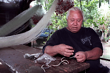
Uncle Walter Kamana, a master ocean gatherer, attaches
limu seed plants to a section of rope to be "planted" in the ocean.
Kamana hopes to bring limu back to waters off Ewa,
where it once thrived.
By Kekoa Catherine Enomoto, Star-Bulletin, Wednesday, May 6, 1998
http://archives.starbulletin.com/98/05/06/features/story2.html
A 60-year-old po'o lawai'a master ocean gatherer calls Ewa the "mother" of limu manauea. Uncle Walter Kamana of Nanakuli Hawaiian Homestead refers to the coastal area from Barbers Point to Nanakuli as the "father." And, the Maili, Waianae, Makaha and Makua communities are the "daughters and sons."
Kamana is responsible for teaching his two children, three grandchildren, nieces, nephews and neighbors about the ocean just as his grandmother, la'au lapa'au (herb healer) Maude Kau'i Hinawale, and his parents taught him.
"I call Ewa the mother because Ewa was the part of the Hawaiian Islands that grew five different types of limu manauea," said Kamana, who is showcased at this weekend's 'Ewa Beach Limu Festival. "I'm one of the boys who knows, because I had to catch the train past Barbers Point and go up there and pick limu."
Kamana said this month witnesses a wave of limu activity. He and members of his 'ohana for whom limu gathering is a daily ritual have developed a system of replenishing much-needed limu stocks along the Leeward Coast. The month of May is the start of the three-month harvesting season, the middle of the four-month planting period, and the end of the two-month seeding time.
In his shady garage neatly draped with fishing nets, fishing poles and body boards, with roosters crowing in the background Uncle Walter demonstrated the first planting step: He tucked small limu clumps between separated strands of rope. His 'ohana members use rocks to anchor 50- to 100-foot rope lengths interspersed with the limu seedlings along the ocean floor. Or they twist the rope into a circle, like a hair bun; then anchor it with a rock on the ocean bottom, he said.
To seed limu, one finds limu with seeds little reproductive nodes on its surface; tears the limu into pieces; and disperses them in the ocean. To harvest limu, one must gather limu that is neither too young or too old for best flavor, he said.
But he said two major obstacles militate against the burgeoning of limu as in former times over harvesting, and the pollution from development and harbor dredging.
While Ewa is the mother of limu, his own mother, Margaret Kau'i Ching Kamana, who passed away April 24, nurtured his limu knowledge. "She said, 'Share your ocean mana'o (knowledge) with the people you trust,' " he said. "If you could, better your district or better the Hawaiian people or any nationality of people.
"She had a philosophy," he added. "She said any people that are born in the Hawaiian Islands are Hawaiian. No matter what bad, rough, ugly or discolored she said, 'You help 'em.' So we help one another; I would share my fish, I will share my limu."
Hālau o Puʻuloa, the title and theme of this ʻĀina Inventory, refers to the ‘Ewa district’s numerous harbors or awa-lau.
Halau Puuloa he awa lau no Ewa Expansive is Puʻuloa a harbor for ʻEwa
He awa lau moana na ke kehau An extensive harbor belonging to the Kēhau breeze
He kiowai lua he muliwai no Ewa An abundant, overflowing estuary for ʻEwa
Kamakau, in Ka Po‘e Kahiko, lists and describes other kinds of marine resources for which Pu‘uloa was once famous: The transparent shrimp, ‘opae huna, and the spiked shrimp, ‘opae kakala, such as came from the sea into the kuapa and pu‘uone fishponds. Nehu pala and nehu maoli fishes filled the lochs (nuku awalau) from the entrance of Pu‘uloa to the inland ‘Ewas. Other famous i‘a [food] of ‘Ewa, celebrated land of the ancestors, were the mahamoe and ‘okupe bivalves and many others that have now disappeared. (Kamakau 1991:84) https://www.ksbe.edu/assets/site/special_section/regions/ewa/Halau_o_Puuloa_Full-Ewa-Aina-Inventory_Binder.pdf
Ordy Pond – A unique Kanehili water feature
Ordy Pond – likely from “ordinance” – no known Hawaiian name. 1930’s photos show Ewa Plantation residents in small sampan skiffs fishing or collecting opae ula shrimp in the pond which could be used either as fish bait or as a food garnish with limu.
A 2014 study published in American Antiquity by J. Stephen Athens, Timothy M. Rieth and Thomas S. Dye said Ordy Pond “has some almost unique characteristics” in that coring samples can be used to obtain high-resolution chronological and environmental information dating to and beyond the earliest human habitation on Oahu. Using plant remains analysis, the authors concluded that Polynesian colonization may have occurred between A.D. 936 and 1133. The study described Ordy Pond’s 44 feet of aquatic sediment as the “best-preserved, continuous, high-resolution Holocene sedimentary record in the Hawaiian Islands, and probably in the central Pacific.”
Ewa Plain likely experienced two separate sea level rise events over thousands of years
Scientist Alan Ziegler noted in the Wickler-Tuggles BRAC survey that other sinkholes in the general Barbers Point area seem to occur in emergent reefs representing two different high stands of the sea: an older one whose reef surface in this area is about 40 or 45 feet above sea level, and a younger one that yielded a reef surface of about 25 or so feet. There is some indication from previous work that there may possibly be qualitative and/or qualitative differences in the avian or other faunal remains occurring in sink holes of the two different reefs. (Future sea level rise will cause Ordy Pond to expand over time.)

Ordy Pond by Stephen Athens, Timothy M. Rieth and Thomas S. Dye
https://www.jstor.org/stable/24712731
Ewa Reef, Beach, Limu Toxic Chemical Exposure From Major Navy Dump Site
https://ewa-hawaii-karst.blogspot.com/2017/07/hawaiian-wetlands-chemical-dump.html
The Navy said it spent $1.35 million to clean up munitions-related items from Ordy Pond, a 10,000-year-old limestone sinkhole pond in Kanehili, (former NASBP) which has helped determine when the Polynesians first colonized the Ewa Plain. News reports say the Navy found some old aircraft flares and "spotting" charges which produce marker smoke. No explosive ordnance was ever found at the pond. However Navy contractors with a huge amount of money to spend used heavy bulldozers to construct a massively destructive long roadway into an important Hawaiian archeology area which the Hawaii SHPD chief archeologist, Theresa Dohham, advised against in a letter to the Navy.
According to a 2007 Navy study, Ordy Pond likely was used for the disposal of ordnance-related scrap from the late 1960s to the late 1970s. Why this was done was likely these were pyrotechnics set off for visual and noise amusement and was not an official dump site. In fact the Navy at NASBP was officially dumping massive amounts of toxic waste, fuel oil, PCB transformers, etc. into the large WW-II coral pit north of Ordy Pond along Coral Sea Road. The coral pit was actually a very large natural limestone karst sinkhole which appears on old USGS maps. BRAC archeology studies found many native Hawaiian sites in and around it, however it had no known Hawaiian names associated with it.
Evidence Of Large Karst Sinkholes In Ewa Gentry Community Properties
https://ewa-hawaii-karst.blogspot.com/2014/12/large-karst-sinkholes-in-Ewa.html
Barbers Point - Kalaeloa - Ewa Beach, The Major Karst Sinkhole Ponds And Reef Blue Holes
https://ewa-hawaii-karst.blogspot.com/2015/08/barbers-point-kalaeloa-sinkholes.html
Military junk pulled from Kalaeloa pond raises fresh concerns, February 3 2013, William Cole
The 1.2-acre brackish-water pond, which is about 18 to 19 feet deep with silt and sediment below that.

According to the Navy, a $915,485 contract was awarded to Cape Environmental Management Inc. for the work. Cape has been a Navy NavFac insider contractor for a very long time. They brought in large amounts of heavy equipment -excavators, loaders and backhoes to rake away and basically “nuke” an area around the entire pond, destroying many archeological features that Kanehili Cultural Hui had seen. They also bulldozed a wide and long road inside the pond site and over into an important Hawaiian archeology area for their explosive enjoyment.
The massive scale and redirection of the project's roadway was extremely unnecessary since there were other explosive demolition site alternatives, including an easily accessible former WW-II military rifle and machine gun range directly across from the Ordy Pond entrance. Why wasn’t this logical and far less damaging alternative used instead of massively bulldozing into an extremely sensitive and deep concentration of Hawaiian archeology sites?

The reason the Navy contractors bulldozed the far more damaging long and wide roadway is explained by the insider NavFac contractors all jumping onto the then lucrative rush to construct solar PV farm racket and the HCDA scheme for an “East Kalaeloa Energy Corridor” powerline to service all these future proposed solar PV farms in that east area of Kalaeloa. The massive long and wide bulldozed road matched almost exactly the HCDA route of the proposed “energy corridor” powerline scheme.
Why were all the mangrove surrounding the pond ripped out with heavy tracked machinery and maximum gross weight heavy trucks? This was to permanently destroy as many archeological sites as possible before any archeologists could do a more detailed survey. The heavy equipment was also there to crush any subsurface karst channels to the ocean and turn Ordy Pond into a totally dead pond that could later be filled in by future (Navy insider) land developers. The Navy claimed that they had to destroy so much because there might be “potential explosive items in and around the edge of the pond.” Yet the truth is that the Navy contractors had a pile of UXO remediation money to spend and other agendas like building solar PV farms.

The truth about this Ordy Pond Navy contractor scheme was that congress at the time had made lots of money available for UXO (unexploded ordnance) recovery projects so Navy contractors were ultimately able to snag around $2.5 Million to fully nuke Ordy pond. This also included ex Navy SEAL divers who used metal detectors in the pond, which is 18 to 19 feet at its deepest point with an estimated 44 feet of deeper aquatic sediment which is a gold mine of archeological information about the 10,000 year old pond.

"This entire Ordy Pond project has all the appearances of way too much to spend with way too little documentation," (Ewa historian) Bond said to SA writer William Cole. "There could be very significant impacts to the pond water, underground karst system and very possible destruction of numerous yet undocumented archaeological sites -- and even iwi kupuna burials."
The work could have been done with chainsaws and machetes to better protect the pond environment, Bond said. This is what Hawaii SHPD chief archeologist Theresa Donham had recommended to the Navy. Both Bond and Michael Lee (Kanehili Cultural Hui,) a cultural descendant of Native Hawaiians buried in the area, questioned why an archaeological inventory survey was not conducted for the Ordy Pond site. "How can you say you are protecting archaeological sites when you haven't inventoried them?" Lee asked.
A May 5, 2011, letter from the state Historic Preservation Division to the Navy noted that the Ordy Pond project "area of potential effect" included 18 archaeological features and said an archaeological inventory survey would be "appropriate." The Navy said the project subsequently was revised to "avoid all archaeological resources," so the survey was not done. Bond said that "doesn't appear to be the case at all," adding, "In fact, the entire project has been greatly expanded into the most important and culturally sensitive area on the former base."

Kanehili Cultural Hui (KCH) had been into the site numerous times previously, including with then City Councilman Tom Berg and noted a significant amount of native Hawaiian structures including a very large sand and coral ahu and what looked like a small shallow coral paved pool connected to the pond, possibly for ancient Hawaiian keiki to safely splash in the water. There were also remains of a mid 1900’s paniolo ranch shack or homestead, crockery, well pump and a model T truck chassis. These were also ripped out by Navy contractors.
The Navy archeologist Jeff Panteleo had previously told Mike Lee and John Bond that when the time came to clear the pond that KCH would be notified to be cultural monitors. However we were notified by an area resident that they saw Navy contractors moving in heavy tracked equipment and when we got there Panteleo was sitting in his car smoking a cigarette. We realized that Panteleo was not ever to be trusted about anything as we had previously been told by him that when the the Navy Hunt KREP PV project was getting started that their subsurface surveyors had found a large “void” in the project area and he would give us a copy of the report. Void is a vague way of saying the word “cave,” just as sinkholes are also called “dissolution pits.” Ultimately he never kept his word and gave us the report.
University of Hawaii archeologists had previously gone into study Ordy Pond and the Navy had never advised them of any explosives or any "dangerous situation,” when they were conducting decades of sediment studies in the pond. Again the truth is that Navy NavFac had a pile of UXO money and handed it over to their favorite contractors to have a great time bulldozing everything on a scale that was totally ridiculous.
The Navy had conducted an initial Assessment Study of the Ordy Pond site in 1981 which was followed by an Environmental Baseline Survey, a Remedial Investigation and an Ordnance Survey in 1994 for the BRAC. During this extensive field work, sediment, soil, water and groundwater samples were collected all around the pond. No explosive “ordnance,” was ever found - mostly just some old water soaked flares. Based on these detailed studies it was determined that any “ordnance” at Ordy Pond was recovered and had cleared during the 1994 investigations and surveys.
Stephen Wickler, Ph.D., David Tuggle, Ph.D., July 1997
The wetland known as Ordy Pond (Fig. 3) had not been recorded as a cultural site in previous surveys, even though it is shown on the 1928 USGS map of the area as a fenced, ranching feature (Tuggle and Tomonari-Tuggle 1997b: Fig. 6). There is no known information in Hawaiian traditions regarding the wetland and no recorded Hawaiian name for the locale. However, there is a high probability that this feature was used as a Hawaiian fishpond, despite the lack of traditional information to that effect (W. Kikuchi, pers. comm.).
The Ordy Pond deposition is probably one of the most important in the Hawaiian Islands, based on a comparative evaluation of the results of cores from numerous wetlands in the islands (Athens, pers. comm.). With the Salt Flat (Site 5118), it forms a complementary set of data of unmatched value.
The Hawaiian use of the wetland remains unknown, but there is a reasonable probability that this was a fishpond. As such, this was probably an attraction that resulted in the substantial settlement in the vicinity, represented by Sites 1730-1744.
The pond is a recognized wetland and is protected by federal legislation under the Clean Water Act. At the same time, it is recommended that it be considered eligible to the National Register for the paleoenvironmental information it contains and for the possibility that it was a Hawaiian fishpond (Criterion D). If this possibility can be supported, it would make Ordy Pond a unique cultural feature of the ‘Ewa Plain, and would support a further recommendation for preservation as a cultural feature, as well as a paleoenvironmental resource.
Given the potential of the sediments of the pond, it is of particular importance to emphasize the necessity of protecting the pond from any disturbance during actions associated with environmental clean-up or other activities during the base closure or subsequent re-use. The pond sediment has an extraordinarily high potential for providing substantial information about the environmental history of the region, covering a period of a few hundred years prior to human occupation of the region, through the Polynesian period, and well into the 19th century.
The University of Hawaii studied and sampled Ordy Pond in 1998 and at that time the Navy had said they believed that the pond had been extensively searched and cleared. The pond parcel was planned for a transfer as part of Base Realignment and Closure (BRAC), which is why the Navy did the 1994 ordnance investigations and surveys. When the new congressional pot of UXO remediation money came through the Navy NavFac decided to conduct another new and very expensive survey.
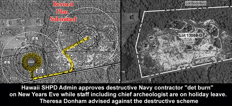
At the time SHPD’s chief archeologist Theresa Donham gave the Hawaii SHPD opinion concerning active bulldozing and grading, around the pond. However her advisory letter was overridden by Hawaii SHPD Administrator Pua Aiu in a letter written and sent out on New Year’s Eve when all of the SHPD staff were on holiday leave. Aiu did NOT actually have the professional experience and accreditation to make this last minute change but that was how she was running Hawaii SHPD. Eventually she had to resign from SHPD however still has a high paying Hawaii DLNR job where she makes pro developer decisions for Hawaii SHPD.
Then Civil Beat writer Sophie Cocke did several excellent insightful articles about Hawaii SHPD
Head of Historic Preservation Agency Resigns Amid Criticism, 2013
https://www.civilbeat.org/2013/07/19446-head-of-historic-preservation-agency-resigns-amid-criticism/
Some Native Hawaiian cultural practitioners and historians are protesting the Navy’s method of cleaning up unexploded ordnance at a sinkhole site within Kalaeloa (once the site of Barbers Point Naval Air Station). The Honolulu Star Advertiser reported “Military junk pulled from Kalaeloa pond raises fresh concerns'' February 3, 2013.
According to a 2007 Navy study, Ordy Pond reportedly was used for the disposal of ordnance-related scrap from the late 1960s to the late 1970s. But no detailed information about the types of ordnance disposed of was available, according to the Navy report. The study also said that during site surveys, the Navy found and removed flares and small arms ammunition, but no explosive ordnance was discovered.
One concern about the cleanup is the use of heavy equipment to remove mangrove and the detonation of munitions. The ʻEwa plains have some of the most unique geological, biological and cultural formations in the Hawaiian islands. Critics of the Navy’s actions fear that such activity will harm the cultural sites: John Bond, an Ewa Beach historian, said Ordy Pond has become a “major destruction site” with all the heavy equipment work.”
“This entire Ordy Pond project has all the appearances of way too much to spend with way too little documentation,” Bond said. “There could be very significant impacts to the pond water, underground karst system and very possible destruction of numerous yet undocumented archaeological sites — and even iwi kupuna burials.”
The work could have been done with chainsaws and machetes to better protect the pond environment, Bond said. Both Bond and Michael Lee, a cultural descendant of Native Hawaiians buried in the area, question why an archaeological inventory survey was not conducted for the Ordy Pond site. “How can you say you are protecting archaeological sites when you haven’t inventoried them?” Lee asked.
A May 5, 2011, letter from the state Historic Preservation Division to the Navy noted that the Ordy Pond project “area of potential effect” included 18 archaeological features and said an archaeological inventory survey would be “appropriate.” The Navy said the project subsequently was revised to “avoid all archaeological resources,” so the survey was not done. Bond said that “doesn’t appear to be the case at all,” adding, “In fact, the entire project has been greatly expanded into the most important and culturally sensitive area on the former base.”

The Ordy Pond B-52 Bomb Crater Story...
Ordy Pond Navy Demolition Story On KITV, Catherine Cruz, Friday Jan 11, 2013
The Navy never did an AIS (Archeological Inventory Survey), never consulted well known OHA and OIBC recognized Ewa native Hawaiian cultural practitioner, (and recognized Navy Section 106 cultural advisor) Michael Lee, as Navy contractors ran heavy equipment in areas Hawaii SHPD had stated concerns about, and has now run a major new road into another very sensitive major Hawaiian archeological area for the purpose of building a bunker and destroying any found materials- which so far has been approximately two very old Vietnam era flares.
The site currently looks like a B-52 bomb crater surrounded by a large portable site office and heavy equipment, large pontoon boat, etc., completely exposed to the DHHL Hawaiian Raceway Park dirt track, which will be running races this Sunday! This will cause further major site pollution and make any use of it as a "wildlife preserve" a major farce.
The massive heavy equipment operation is likely now doing significant below ground damage with oil and fuel leakages. Accurate pond water tests now will likely be very difficult.
Michael Lee and John Bond are very concerned that the heavy equipment is smashing sites and smashing the karst coral structures which will drain or lower the pond's water level and effectively
kill it off like the other area springs that once contained active fresh water flows. Heavy equipment is very likely to fracture the pond’s karst water system and could cause the pond to become another dead zone like the other Hawaiian springs that were killed off by the Navy.
The Ordy Pond site had been previously studied 20 years ago (by Bishop Museum in 1991) and that "an update on the condition of the site is still needed." Eighteen archeological features within a 176 by 151 meter area were noted at the time. This recorded information was by no means a full archeological survey. Further- "It is likely that native Hawaiians may attach religious or cultural significance to Site 1730 (the adjacent structures) and to Ordy Pond (Site 5104)". "We would appreciate the opportunity to review the AIS report prior to concurrence of a pond area clearance determination."
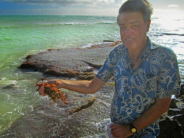
Michael Lee stated that the underground karst water flows that feed the pond and which flows down directly to the beach area where he collects limu for medicinal and cultural purposes. Contamination
of this food and medicine resource would be very serious. SHPD Administrator Pua Aiu however in a subsequent letter to the Navy accepted the idea that the Navy had consulted with "Hawaiian Community Leader Mr. Shad Kane" and that the project "will have no adverse effect." (Shad Kane had a long and fruitful relationship with Navy archeologist Jeff Panteleo to approve all Navy projects.)
Ewa marina foe persists despite Haseko’s change of plans
https://www.staradvertiser.com/2011/12/11/business/ewa-marina-foe-persists-despite-hasekos-change-of-plans/ Ewa resident Michael Lee stands near the area where developer Haseko plans to develop a marina at Hoakalei Resort community.

The Royal Bones Of `Ewa - A Visit With Michael Kumukauoha Lee https://www.youtube.com/watch?v=M6uMqAlLPrE
Mike Lee found even more would come from washing away the sands of Hau Beach killing sea life including limu, critical to the areas ecosystem, when he discovered royal burial caves containing priceless artifacts and remains of O`ahuʻs ancient rulers to whom he was related, he knew he had to act. Donʻt miss our visit with Mike as he tells us the story of this amazing place filled with ancient history of Hawai`i and his remarkable plans to save it for all to see: The Royal Bones Of `Ewa.
Also: Mike Lee at Kalaeloa Pond Site #2 Kalaeloa Airport, March 15, 2013
https://www.youtube.com/watch?v=g-uDE-AolNY
1999 Naval Air Station, Barbers Point, Hawaii, BRAC Disposal and Reuse of Land
“Ordy Pond is hydraulically connected with the ocean. The water level fluctuates with the tide.”
Naval Air Station, Barbers Point, Hawaii, the Diposal and Reuse of Land and... - Google Books
2004 Board of Water Supply- The only (known) surface water feature at Kalaeloa is Ordy Pond. The pond hydraulically connects with the Pacific Ocean and its water surface level fluctuates with the tide.
2003 FEA Army Guard, Kalaeloa-The only (known) water feature at Kalaeloa is Ordy Pond. The pond hydraulically connects to the Pacific Ocean and its water surface level fluctuates with the tide.2014 DEA Kalaeloa Heritage Park-The pond’s surface area is approximately one acre. Like all anchialine ponds, it is hydraulically connected to the ocean, and the water level fluctuates with the tide.
A local water scientist, PhD (name omitted for protection) stated “There is a tidal signal (pulse wave) that travels underground about a mile” and a half twice a day due to tidal change (in Ewa). “The karst is very permeable and very transmissive” “Talk to drillers who can describe drills dropping as they bore down…” http://health.hawaii.gov/wastewater/files/2015/09/OSDS_OAHU.pdf Hydraulic conductivities: On the high end are coral gravels and reef limestones. These coral reef remnants have the highest hydraulic conductivities of any formation in Hawaii with estimated values as high as 30,000 ft/d based on tidal response analysis (Oki et., 1996).
Navy KREP: Broken Agreement Caused Karst Collapse And Subsurface Damage
https://kanehili.blogspot.com/2015_09_01_archive.html

Ewa Plain Karst


Ewa Plain Karst: A Precise Cut Into The Karst For An Amazing View Back In Time
https://ewa-hawaii-karst.blogspot.com/2014/12/ewa-plain-karst-john-bond.html
Karst water systems covered under the US Clean Water Act
Most people in Hawaii don’t know that the US mainland has many karst caves and water systems which are used for drinking water in many rural areas
"An unbroken surface or shallow subsurface hydrologic connection to jurisdictional waters may be established by a physical feature or discrete conveyance that supports periodic flow between the wetland and a jurisdictional water. Water does not have to be continuously present in this hydrologic connection and the flow between the wetland and the jurisdictional water may move in either or both directions.
The hydrologic connection need not itself be a water of the U.S. A shallow subsurface hydrologic connection is lateral water flow through a shallow subsurface layer, such as may be found in steeply sloping forested areas with shallow soils, soils with a restrictive horizon, or in karst systems."

A major karst cave site in Ewa in the 1970's was being destroyed by workers when the opening grew so large work finally had to be stopped and archaeologists were called in. After a fairly quick examination and some photos it was destroyed. Pre-Western contact Oahu has many, many native Hawaiian stories of very large sea caves and coral water channels. Schools of mullet were well known to pass under Oahu from places such as Hawaii Kai to Kailua's Enchanted Lakes via underground lava tubes connected to karst cave entrance portals.
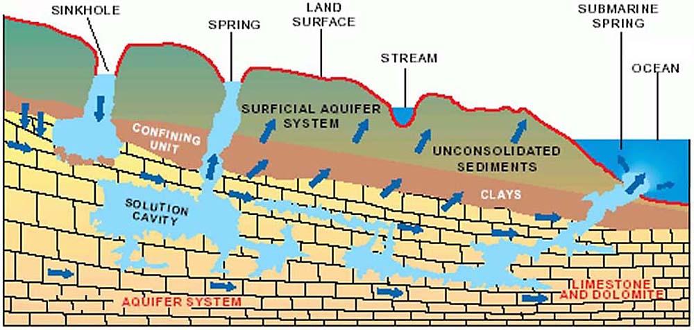
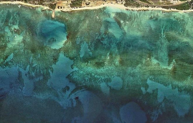
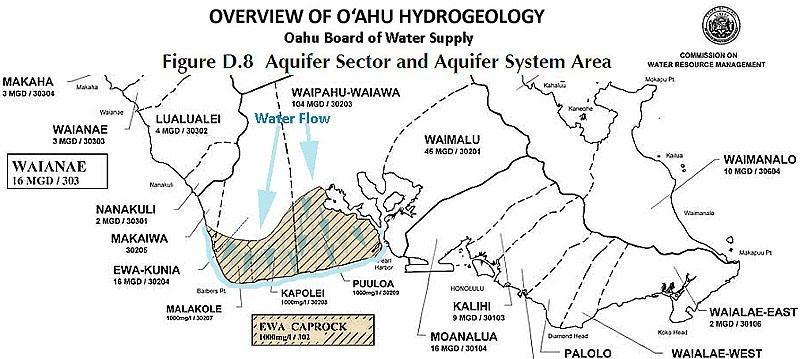
The Ewa Plain covers the southwestern corner of the island of Oahu, Hawaii. The coastal portion of the Ewa Plain is overlain by reef limestone material deposited during numerous past high stands of sea level. The uppermost limestone layer is called the Upper Limestone Aquifer (ULA).
Deep karst waterway channels flow underground through the entire Ewa Plain
Mike Lee: Mountain water and rainfall streams flow directly through the Ewa Plain ancient coral reef and into the shore and reef system, affecting the health and pollution of these traditional native Hawaiian resources which are also the basis for Oahu's marine ecosystem.
A huge karst cave was discovered during the construction of the Barbers Point Deep Draft Harbor
Construction of Barbers Point was completed in 1985, with a total project cost of $59 million
Honolulu District | Civil Works Projects | Barbers Point (army.mil)

The Large Ewa Karst Cave Destroyed By Developers After A Quick Archaeology Look
AND was a physically and hydrologically connected estuary for aquatic life
A sizeable phreatic dissolution cave accidentally opened in 1973 during quarrying Kalaeloa Harbor operations ("Site B6-139") was an ''unmodified wet sink-cave.”

Quarry operators deliberately tried to fill this cave before 1977 archaeological and palaeontological salvage studies (Sinoto, 1978, p. 45) but it was too large. . . the west sink (cave) contains well-formed stalactites and stalagmites, some of which are subsurface.
Dredging for the new barge harbor destroyed the most notable cave known in the Ewa Karst without it even receiving a name (Figures 4,5). For unclear reasons, it was rarely even termed a cave and was variously referred to as a "flooded sink", a "wet sink (cave)", etc. It quickly became famous in palaeontological circles because of its content of bones of extinct birds.
Then it was destroyed in order to construct the farthest reaches of the barge harbor
They also noted water level fluctuations of 40cm (16 inches) even though the cave is almost 2 km (1.2 miles) from the shore. However it was left to archaeologist Aki Sinoto to provide details about the cave. He termed it "a unique flooded sinkhole'', and found that it measured 11 m (36 feet) in diameter.
Fresh to brackish water filled 2/3 of parts of the cave. A nocturnal marine isopod, blue-green algae, and minute red shrimp (Holocaridinea rubra) were observed but the primary finding was the rich deposit of intact bones of subfossil-and-extinct birds (Sinoto, 1978.)
The Ewa Karst is the largest on the island of Oahu
William R. Halliday The Cave Conservationist February 1998
It covers at least 50 km2 (19 square miles) in the southwest corner of the island of Oahu. It is a semitropical littoral karst formed on porous, permeable algal and coralline reef deposits formed during at least three high stands of sea level.
From present sea level these formations rise to an altitude of about 20 m (65 feet.) Tidal fluctuations extend inland from the shore line but freshwater at least 10 m (33 feet) deep has been found within 2 km (1.2 miles) of the shore, floating on salt water in the form of a Ghyben-Herzberg lens.
The U.S. Geological Survey Ewa Quadrangle shows numerous sinking streams and closed depressions within the Ewa Karst.
Despite its impressive extent and archaeological and palaeontological values, the Ewa Karst is almost entirely unknown to karstographers and speleologists.
SINKHOLES

Sinkholes can be classified into different types based on their geological features.
Sinkhole caves are formed through a process called chemical weathering, which involves the slow dissolution of the limestone by slightly acidic rainwater. Rainwater becomes acidic when it interacts with carbon dioxide (CO2) in the atmosphere, forming carbonic acid (H2CO3). This weak acid dissolves the calcium carbonate (CaCO3) present in the limestone, creating underground cavities and channels.
Types of Sinkholes – in ancient Kanehili these fresh and sometimes brackish waters contain Opae ula native shrimp. They have also been found to contain ancient bird bones- non flying and sea birds.
Open sinkholes: These are sometimes characterized by a large, open body of water, similar to a pond or lake, such as Ordy Pond in ancient Kanehili. The surface layer has completely collapsed, exposing the water to the open air. Ordy Pond is close to sea level and has measurable tidal fluctuations. Other sinkholes can be extremely small holes, 2-3 feet in diameter and very deep into fresh water caves and subterranean streams, Semi-open sinkholes: These have partially collapsed surface layers, creating an opening that allows sunlight to enter while still retaining some of the cave-like features.
Cave sinkholes: These are completely enclosed within a cave or underground chamber, with no direct access to sunlight. They can have intricate formations, such as stalactites and stalagmites, created by mineral-rich water dripping from the cave ceiling over thousands of years. Caves like these have been found on Oahu. Other examples of Oahu ancient cave remains are Waianae’s “Mermaid Caves.”

Mermaid Caves | Exploring a local Oahu gem
https://www.youtube.com/watch?v=DNsoP11gJaI
https://www.youtube.com/watch?v=C7I81oSyjd4
Cenotes are part of a more extensive hydrogeological system called an aquifer, which is an underground layer of water-bearing permeable rock. In the Yucatan Peninsula, this aquifer is mainly composed of limestone, and the cenotes act as natural access points to the underground water reserves.
Ancient Maya believed that caves and cenotes (pronounced seh-NO-tehs) sinkholes were portals to another world and that certain caves were considered the holiest places on Earth, part of a mystical underworld outside of normal time and space. Deities dwelled in these caves, and Mayan priests communed with armadillos as an "avatar" and a jaguar deity similar to native Hawaiian aumakua concepts that guide souls in the Leina a ka uhane – spirit leaping place.
Like native Hawaiians on the plains of Kaupe’a and Kanehili, Mayans used the fresh water in sinkhole caves for agriculture and were considered as life-giving and sacred.
The Moiliili Karst Formation – large caves in lower Manoa
https://ewa-hawaii-karst.blogspot.com/2013/06/Oahu-Karst-Caving.html
https://lookintohawaii.com/hawaii/47144/mermaid-cave-tunnels-activities-oahu-waianae-hi
https://imagesofoldhawaii.com/moiliili-karst-moiliili-water-cave/
https://www.liveyouraloha.com/mermaid-cove/
Mayan Caves: Places of Sacred Rituals (nationalgeographic.org)

Goddess Hi’iaka’s Spring of Hoakalei Which Still Exists Today
https://www.youtube.com/watch?v=vr9BK2IdSgs
Karst
"An unbroken surface or shallow subsurface hydrologic connection to jurisdictional waters may be established by a physical feature or discrete conveyance that supports periodic flow between the wetland and a jurisdictional water. Water does not have to be continuously present in this hydrologic connection and the flow between the wetland and the jurisdictional water may move in either or both directions.

The hydrologic connection need not itself be a water of the U.S. A shallow subsurface hydrologic connection is lateral water flow through a shallow subsurface layer, such as may be found in steeply sloping forested areas with shallow soils, soils with a restrictive horizon, or in karst systems.
A major karst cave site in Ewa in the 1970's was being destroyed by workers when the opening grew so large work finally had to be stopped and archaeologists were called in. After a fairly quick examination and some photos it was destroyed. In pre-Western contact Oahu there are many native Hawaiian stories of very large sea caves and coral water channels. Puuloa – Pearl Harbor once had large sea caves used by Ewa sharks and the Puuloa shark deities (Kaʻahupāhau and her brother Kahiʻukā.) Schools of mullet were well known to pass under Oahu from places such as Hawaii Kai to Kailua's Enchanted Lakes via underground lava tubes connected to karst cave coast line entrance portals.
Deep karst waterway channels flow underground through the entire Ewa Plain
Ewa Hawaii Karst: The Ewa Plain Karst is the largest of several karsts on the island of Oahu (ewa-hawaii-karst.blogspot.com)
The Ewa Plain Karst is the largest of several karsts on the island of Oahu
https://ewa-hawaii-karst.blogspot.com/2014/12/Ewa-Karst-largest-on-Oahu.html
Ewa Plain Karst: A Precise Cut Into The Karst For An Amazing View Back In Time
https://ewa-hawaii-karst.blogspot.com/2014/12/
US Fish & Wildlife Demonstrates How Ewa Plain Karst Can Be Restored
https://ewa-hawaii-karst.blogspot.com/2014/12/us-fish-wildlife-ewa-preserve.html
Could Ewa's Huge Underground Karst Waterways And Caves Really Exist?
https://ewa-hawaii-karst.blogspot.com/2015/09/

1941 Marine Ewa Airfield – (ancient Kanehili) Report of Large Ancient Subterranean Caverns
During the field survey for the Kalaeloa Solar Farm a verbal report from a contractor stated that boring data for the Ewa Field panhandle Hunt Corp – Navy KREP solar PV site revealed a large 9 foot deep hole which had been filled back to level during Ewa airfield construction. This information matches with Ewa Field USMC Command History which stated that the area had numerous "Subterranean Caverns."
1925 Ewa Mooring Mast and later WW-II historic military documentation, air photos and ground surveys all documented this area as having hundreds of karst caves and sinkholes. Some have Hawaiian burials, some had agricultural crops in them. Water flows in them after heavy Waianae mountain rains.
“Open Space/Recreation. This land area would comprise mostly passive open space land uses and preserve/cultural park space. These parcels contain a relatively high density of cultural and archaeological sites.”
FINAL REPORT – MAY 2007 CENTRAL OAHU WATERSHED STUDY
The U.S. Geological Survey Ewa Quadrangle shows numerous sinking streams and closed depressions within the Ewa karst.
Page 68: An interesting ecosystem to note within the Ewa Plain is a network of karsts (pit caves, or sinkholes). They could also be termed phreatic caves, which develop below the water table.
The Ewa Karst is the largest of several karsts on Oahu, but possibly the least studied. There are approximately 12,000 acres of exposed reef from Kahe Point to Puuloa, preserving the remains of ancient plants and animals, particularly shells, extinct birds, and two bats, of which one is new to science. Page 58: The U.S. Geological Survey Ewa Quadrangle shows numerous sinking streams and closed depressions within the karst, some man made.
Page 70: Some remaining sinkholes of the Ewa Karst are home for Opae ula (Halocaridina rubra), tiny brackish water shrimp. A natural sinkhole with these shrimp is found near Chevron’s Rowland’s Pond preserve. Two to three artificial ponds were dug by the Division of Aquatic Resources (DAR), two of which filled back up with water.
The “Possible Northern Extension” of the Ewa Karst is where the Ewa Plantation intentionally used water sluices (which is well documented) to wash hillside soils down to cover the Karst. In many areas in Ewa the Alluvial soil is only a few feet deep.
2.9.5.9 Karst Protection: In 2001, the Estate of James Campbell erected a substantial chain-link fence to protect eight acres of karst with at least 100 sinkholes from destruction by nearby quarry operations. Some other areas, “B6-137” and “B6-22” have been fenced due to efforts by former Bishop Museum vertebrate zoologist Alan Zeigler.
Page 234: Receiving surface and ground waters are both susceptible to contamination from these pollutants. Contaminants can reach ground water quickly through fractured rock formations or sinkholes in karst areas, such as that found in Ewa. Groundwater is more sensitive to contamination in these areas because runoff may pass directly into the subsurface with little if any infiltration through the soil, a process that typically filters at least some pollutants.
Opae Ula (Holocaridinea rubra)
Footnote 58: Association of Hawaiian Civic Clubs, “Resolution No. 01-3, Commending the Estate of James Campbell for their Protection of the Ewa Karst Sinkholes,” November 10, 2001, 42nd Annual Convention of the Association of Hawaiian Civic Clubs at Honolulu, Hawai`i.
Other professional hydrology research shows that the twice a day tide change can be measured up to a mile inland beneath the Ewa Plain.
Development toxic chemicals are either absorbed by the native birds, shrimp and plants, or they get flushed into the nearby reef and ocean which is a physically and hydrologically connected estuary for aquatic life
These amazing Ewa Ancient Kanehili Opae Ula endangered native shrimp survive under extremely harsh and polluted conditions under the Ewa Plain Karst and prove that the entire subsurface which hasn't had ALL its karst waterways and caves destroyed by developers.

Mike Lee: Mountain water and rainfall streams flow directly through the Ewa Plain ancient coral reef and into the shore and reef system, affecting the health and pollution of these traditional native Hawaiian resources which are also the basis for the Ewa Kanehili marine ecosystem.
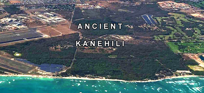
Ancient Kanehili – or what is left of it, largely due to the ironic fact that it was once a major military air base. In fact two airfields: MCAS Ewa Field and NAS Barbers Point. Coral Sea Road cut down the middle dividing the Marine Corps and Navy bases in 1942 after major WW-II expansion began. While destroying many ancient sites this also led to numerous nearly miraculously untouched native sites and trailways. Prior to the entire air base closure in 1999, there were years of required Navy BRAC archeology site surveys and detailed documentation.
They didn’t find everything that was out there however it was enough to show that this area known as Kanehili was a major ancient Hawaiian habitation area which received large amounts of fresh mountain water though sub surface water channels accessed by deep sinkholes and caves. The population was rapidly expanding up until the 1820’s when 90% of the Ewa Plain population rapidly died off from the introduction of western diseases.
The Expansion of the western cultural era onto the Ewa Plain
James Campbell arrived and in 1877 purchased 41,000 acres of the Ewa District for $95,000. Many thought that this was crazy however Campbell knew there was a vast subsurface water supply on the Ewa Plain which Hawaiians called “Wai-Aniani” (crystal waters.)

James Campbell – Campbell Estate
https://en.wikipedia.org/wiki/James_Campbell_(industrialist)
2005 JC history-3 (jamescampbell.com)
Honolulu business entrepreneur Benjamin Dillingham included among his friends King Kalakaua and Queen Liliuokalani. He leased Campbell's Ewa Plain lands to start the Ewa sugarcane plantation (EPco) and obtained a royal government railroad charter from King David Kalakaua.
By 1892, the Oahu Railway & Land Company (OR&L) narrow gauge railway line was 18.5 miles long, reaching his Ewa Plantation Company property. The Ewa Plantation became highly successful due to the rich Waianae volcano soil and the vast amount of subsurface water. The railway transported the ever increasing sugar harvests to the Honolulu dockside where it was processed in California into pure sugar and used in a wide array of products.
Dillingham also created the Hawaiian Fiber Company, which operated a sisal plantation directly makai (south) of the main OR&L line, however this ultimately failed. The legacy of this was that the sisal plants fed on the subsurface springs and spread everywhere as seen today.
https://en.wikipedia.org/wiki/Benjamin_Franklin_Dillingham
https://en.wikipedia.org/wiki/Oahu_Railway_and_Land_Company
https://www2.hawaii.edu/~speccoll/p_ewa.html
https://imagesofoldhawaii.com/sisal/
The military arrives on the Ewa Plain and ultimately WW-II
The 1925 Ewa Mooring Mast Field eventually became Ewa Field in 1941 and was leased through Dillingham and Campbell land holdings.
Ewa Mooring Mast Field - Two Main Phases of the Ewa Mooring Mast – 1925 and 1932
https://barbers-point.blogspot.com/2023/07/ewa-mooring-mast-field-two-main-phases.html
The December 7, 1941 IJN attack on Oahu changed everything, including access to ancient trails that had been abandoned by the 1820’s by a rapidly declining Ewa Plain native Hawaiian population. Oral histories of older Ewa Villagers and Oahu residents state that people still used the trails to go fishing and pick limu until the outbreak of war closed them off for decades.
BRAC! NAS Barbers Point Base Realignment And Closure A Twisted Tale
https://barbers-point.blogspot.com/2013/09/Navy-Insider-Land-Deals.html
The 1995-99 BRAC- Base Realignment and Closure process was turned over to a community commission that made a few good decisions and a lot of bad ones. Making things much worse, the Hawaii legislature turned down the chance for the State to acquire nearly all of it. And much worse, an extremely bad and some would say corrupt land deal was made by top Hawaii politicians to turn a significant portion of Kalaeloa (a fake name) over to the Hunt Corp of Texas, a private family land developer based in El Paso Texas. Never satisfied with their huge profits, Hunt Corp continuously sues the US Navy for more money. The case is still ongoing.
The Navy BRAC closure of NAS Barbers Point required years of detailed archeological and historic documentation (1995-1997)
However recent project surveys continuously find ever more undocumented sites, trails and cultural features in what is today called “Kalaeloa,” ancient name
Kanehili (west coastal area called Kualaka’i)
Kualaka’i is the location of Hi’iaka’s legendary Spring of Hoakalei
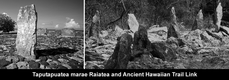
The concept of Kahiki, the ancestral homeland for Kānaka Maoli (Hawaiians.) Kahiki is the symbol of ancestral connection to ancient Polynesia.

KEALAIKAHIKI
The Hawaiian identity is from a Polynesian heritage shaped by the oceanic universe, Moananuiākea. Understanding Hawaiʻi’s connections to the greater Pacific world is fundamental for Hawaiians. The pathway to the motherland, place of origin, is Kahiki.
https://kaiwakiloumoku.ksbe.edu/kealaikahiki
Ke-ala-i-kahiki, the Pathway To Kahiki... “Kahiki Homeland” is the general reference to the lands that Hawaiian ancestors migrated from and sailed back to on return visits. Hawaiʻi shares a strong cultural affinity with the Society Islands, the Tuamotu Archipelago, and the Marquesas Islands.
Raʻiātea, whose ancient name is Havaiʻi, is the location of Taputapuātea Marae, a highly sacred religious site associated with voyaging, governance, and Eastern Polynesian chiefly lineages. The heʻe/feʻe (octopus) is a metaphor for Raʻiātea as the center of a cultural alliance consisting of island groups that are under the influence of its radiating tentacles — the northernmost extremity being Hawaiʻi.


NAVY is supposed to follow its own rules and regulations but let's Hunt Corp of Texas destroy identified historic and archeology sites on federal public lands in HCDA Kalaeloa
SECNAVINST 4000.35A, Section 4.b
Protection of the nation's heritage is an essential part of the Department of the Navy (DON) mission - defense of the people, territory, institutions and heritage of the United States. According to SECNAVINST 4000.35A, Section 4.b, "The DON is a large-scale owner of historic buildings, districts, archeological sites, ships, aircraft and other cultural resources.
Protection of these components of the nation's heritage is an essential part of the defense mission, and the DON is committed to responsible cultural resources stewardship." SECNAVINST 4000.35A establishes policy and assigns responsibilities within the Department of the Navy for fulfilling legally required cultural resource requirements.
1995 (Tuggle and C. Erkelens) Interpretive Trail Development Study, NAS Barbers Point. Appendix F, in H. David Tuggle, Archaeological Inventory Survey for Construction Projects at Naval Air Station Barbers Point. Prepared for Belt Collins Hawaii. International Archaeological Research Institute, Inc., Honolulu.
1995 A Cultural Resource Inventory of Naval Air Station, Barbers Point, O‘ahu, Hawai‘i: Part I: Phase I Survey and Inventory Summary. Archaeological research services for the proposed cleanup, disposal and reuse of Naval Air Station, Barbers Point, O‘ahu, Hawai‘i (Task 2a). Pre Final report prepared for Belt Collins Hawaii, Honolulu. International Archaeological Research Institute, Inc., Honolulu.
1994 Cultural Resources of Naval Air Station, Barbers Point: Summary, Assessment and Research Design. Prepared for Belt Collins Hawaii and the U.S. Navy. International Archaeological Research Institute, Inc., Honolulu.
1991 Archaeological Survey of Two Demonstration Trails of the Hawaii Statewide Trail and Access System. Prepared for Na Ala Hele Statewide Trails and Access Program, Department of Land and Natural Resources. International Archaeological Research Institute, Inc., Honolulu.

Subterranean caves and shoreline spring outlets sustain the Ewa Kanehili coastal ecosystem and fisheries which feed in the rich freshwater nutrients for limu and the entire Ewa shoreline ecosystem - This fresh spring water has been gradually choked off and is turning the reef into an underwater desert devoid of sea life.
Ewa Plain Hawaiian Traditional Cultural Places (TCP) Documented
Traditional Cultural Properties Report Honouliuli Ahupuaa (hawaii.edu)
Traditional Cultural Properties Report Honouliuli Ahupua‘a Honolulu Rail Transit Project Technical Memorandum March 2012 Prepared for: Honolulu Authority for Rapid Transportation
The focus of the HART TCP study is the Hawaiian perspective of the land and the relationship between
the cultural and natural environments. Traditional Hawaiian culture views the land as being sacred.
This report presents findings of a Traditional Cultural Properties (TCP) study for the Honouliuli ahupua’a that crosses the Honolulu Rail Transit Project

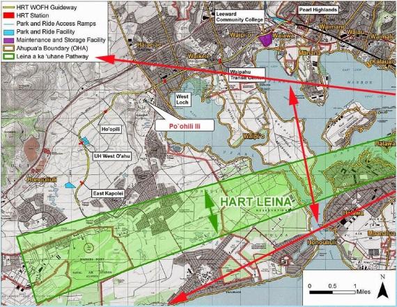
ABOVE – HART Rail TCP map of the Leina a ka uhane Historic TCP district – under federal TCP contract
The HART RAIL Programmatic Agreement contains fourteen stipulations that resulted from consultation among the FTA, the Advisory Council on Historic Preservation, the State Historic Preservation Division (SHPD), the City and County of Honolulu, the United States Navy, the Office of Hawaiian Affairs and Native Hawaiian civic clubs and other organizations. Stipulation II – Traditional Cultural Properties – requires additional study be conducted to identify any previously unidentified TCPs within the Area of Potential Effect (APE) defined by FTA, in consultation with SHPD, for the corridor; meeting with the SHPD and consulting parties (like Kanehili Cultural Hui) to discuss and identify potential TCPs; and completing eligibility and effects determinations and mitigation measures if appropriate – prior to start of construction. (In fact HART rail later DENIED all four Ewa Plain TCP’s presented by Kanehili Cultural Hui and has since refused acknowledging the highly documented and mapped National Register eligible Leina a uhane as a recognized native Hawaiian TCP. This showed the really massive scale of outright lying by HART, FTA, SHPD-DLNR!)
TCPs are “places of religious and cultural significance” (NHPA Section 101 and NHPA regulations,
Section 106). NHPA guidance (Parker and King 1990:1) defines a TCP as a property “… that is eligible
for inclusion in the National Register because of its association with cultural practices or beliefs of a
living community that (a) are rooted in that community’s history, and (b) are important in maintaining the continuing cultural identity of the community.” TCPs are integral to a community’s history and identity. Yet HART rail refused to honor PA required Section 106 EWA KANEHILI TCP identifications!
West Oahu Leina A Ka Uhane Spirit Pathway Recognized By Federal Transit Administration
http://honouliuli.blogspot.com/2015/07/Leina-a-ka-uhane.html
FTA and HART Decide Sacred Hawaiian Spirit World Starts At End Of East Kapolei Rail Station
http://honouliuli.blogspot.com/2015/01/leina-ka-uhane-wahi-pana.html
Ewa Plains HART Guideway and Stations Intersects with 1825 Malden Trail Survey
https://kanehili.blogspot.com/2014/06/ewa-plains-1825-Malden-Trails.html
Traditional Cultural Properties Report Honouliuli Ahupua‘a Honolulu Rail Transit Project Technical Memorandum March 2012 Prepared for: Honolulu Authority for Rapid Transportation
Traditional Cultural Properties Report Honouliuli Ahupuaa (hawaii.edu)
The people who are best able to identify these places and their importance are the members of the
community, (like Kanehili Cultural Hui) that understand their value. Any place identified as a TCP is important to the people who understand its value. (like Kanehili Cultural Hui)

HART Rail totally lied when it never followed through with a signed agreement and promise in the HART Rail PA that it would, REGARDLESS OF EFFECT DETERMINATION, COMPLETE NRHP NOMINATIONS that meet NRHP CRITERIA.
FTA TCP Contract: to determine whether previously unidentified places of religious and cultural significance might be in or near the Project’s APE (Area of Potential Effect); and, b) if such places did exist, whether they might be National Register eligible. (National Historic Preservation Act 1966.)
The documentation provided here is a summary of the TCP study research and HART‟s recommended
determination for a property identified in a portion of the West Oahu Farrington Highway (WOFH)
Guideway Section located in the Honouliuli ahupua‘a.
The Leina a ka uhane MEETS the eligibility criteria! Yet they completely later LIED and RENEGED!
SHPD admin Alan Downer met with Mike Lee and John Bond of Kanehili Cultural Hui several years ago and said he (SHPD) would SUPPORT the NR nomination of the the Leina a ka uhane, yet since Mike Lee’s death, Downer will not respond to phone calls or emails about his promise. Likely because his bosses (including Hunt Corp, Navy, HCDA) are telling him to not respond.
NOTE: The Leina a ka uhane is extremely well documented by Kepa Maly, KumuPono, and FTA, HART and SHPD-DLNR all AGREED IN OFFICIAL DOCUMENTS that it was a NR TCP-Historic District.

Programmatic Agreement (PA) signed 2011 – so that rail could start construction
http://hartdocs.honolulu.gov/docushare/dsweb/Get/Document-20355/FINAL%20PA%20Signed_Combined.pdf
Here is what HART Rail said were National Register TCP’s – The Leina a ka uhane has integrity of relationship and condition under category A and B. After doing this they then said it didn’t affect rail construction at all and then later totally RENEGED on even recognizing it AT ALL, which is the position of HCDA, DLNR-SHPD and the big developers who run Hawaii.
The Kanehili area still has the most integrity of relationship and condition under category A and B for Leina a ka uhane recognition as well as numerous other sites along Coral Sea Rd. HCDA likes to point out Kalaeloa Heritage Park (KHP), however KHP really only contains a small area of many more sites very culturally important and significant in Kanehili.
Kanehili Leina A Ka Uhane Spirit Pathway Recognized By Federal Transit Administration
http://honouliuli.blogspot.com/2015/07/Leina-a-ka-uhane.html
FTA and HART Decide Sacred Hawaiian Spirit World Starts At End Of East Kapolei Rail Station
http://honouliuli.blogspot.com/2015/01/leina-ka-uhane-wahi-pana.html
Many Hawaii SIHP sites in Kanehili and more that aren’t documented
Numerous important large sinkholes, caves are found along Coral Sea Road on the eastern side and contain remarkable and very deep karst sinkholes, some still carry spring water which flows from the Waianae volcanic mountain to the Ewa shoreline. Some sinkholes were found to have contained ancient bird bones while others had iwi kupuna. The water flow is crucial for the spawning of Hawaiian limu varieties found on the Ewa shoreline and which forms the food chain ecosystem for reef fish, shellfish, turtles, seals, and pelagic fisheries.

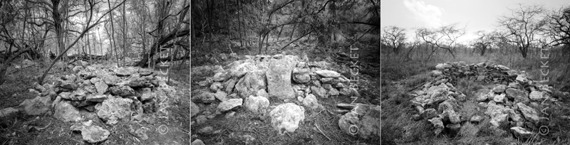
The Oahu BWS held meetings in 2013 about Ewa Watershed Management and recognized native Hawaiian Rights and customary practices. ABOVE a karst cave later destroyed by a developer.

Ewa Reef, Beach, Limu Toxic Chemical Exposure From Major Navy Dump Site
https://ewa-hawaii-karst.blogspot.com/2017/07/hawaiian-wetlands-chemical-dump.html
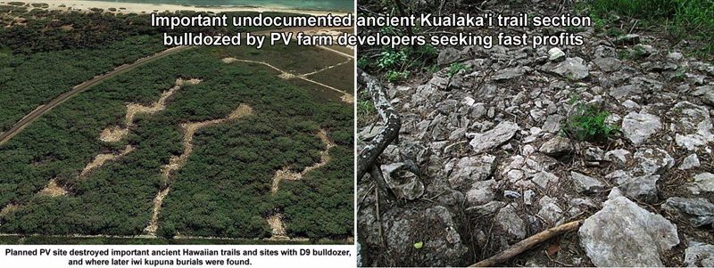
Undocumented ancient Kualaka’i trail section below Kalaeloa Heritage Park was heavily damaged by PV farm developers supposedly doing a “survey” but actually bulldozing major access roadways
Impacts on Native Hawaiian Practices and Culture, Native Hawaiian Law Training
Microsoft Word - 3. NH Traditional and Customary Practices_Summary - June 2022.docx (hawaii.gov)

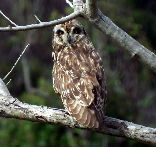
PUEO – Ewa’s endangered aumakua

ABOVE – photos taken in the UHWO, NS Road, former MCAS Ewa, ancient Kanehili- Kaupe’a area described above show that Pueo vary in appearance based upon age, health, foraging and mating season. Developers pay for “Pueo survey’s” which are intentionally designed to not find them.

ABOVE – Pueo resting in an area where they were commonly seen foraging, mating and nesting on UHWO parcels in 2016. After Tom Berg published this information online that the UHWO had workers cut down all of the nesting trees and destroy the entire area likely killing young Pueo hatchlings.
ABOVE young Pueo on a cyclone fence near the KROC center. This apparently same young Pueo was also seen on the former MCAS Ewa boundary fence and another night time cell phone photo showed possibly the same Pueo on a fence by the East Kapolei Fire Station near DHHL offices. The nighttime photo showed what looked like a very frightened and confused young Pueo who may not have survived.

Seeing Barn owls (Tyto alba) are much more common in the area as they appear in the late afternoon, early evening and can be heard screeching in the late evenings hunting for prey. The Pueo and Barn owls have apparently divided up their hunting periods to be compatible. On the Big Island of Hawaii where John Bond spent many years in 1970’s, Pueo were commonly seen all over the Waimea area during the daytime. The intense noise pollution on Oahu has driven Oahu Pueo to be primarily an early morning forager. Car lights and noises often confuse Pueo, especially under 1 year of age causing early deaths.

Save The Hawaiian Pueo Owl
https://www.facebook.com/SavePueoOwl/


The endangered Oahu Pueo owl can be considered a contributing element to a TCP, according to NRHP expert Tom King (Co-author of the NPS NRHP guide National Register Bulletin 38: Guidelines for Evaluating and Documenting Traditional Cultural Properties –TCP)
Oahu endangered Pueo owls are still found on Ewa Plain and along the route of the ancient Hawaiian trails, however developers always submit their bird surveys that never find them. This is because the "studies" by developers are intentionally designed to NOT find them. State DLNR and UH studies are also amazingly if not intentionally incompetent at finding Pueo. Local politicians accept this!
The Canadian Innergex Barbers Point solar project bird survey reported seeing only one Pueo in the early morning on their third development parcel area. They then switched to afternoons and never saw any more. This is very consistent with Pueo activity in this former MCAS Ewa, ancient Kanehili, Kaupe’a area today. Had they gone back to looking in the early morning they would have had more Pueo sightings. Very likely they didn’t want to find any more Pueo in the project area.
Hawaii Super Moon Reveals Rare Endangered Native Pueo In Ewa
http://honouliuli.blogspot.com/2015/09/super-moon-rare-Oahu-Pueo.html
MAUI FAUNA OF THE MONTH: PUEO
https://mauiguide.com/hawaii-owl-pueo/
The Owls Fought The Law and the Owls Won
https://www.sacred-texts.com/pac/hft/hft22.htm
BATTLE OF THE OWLS
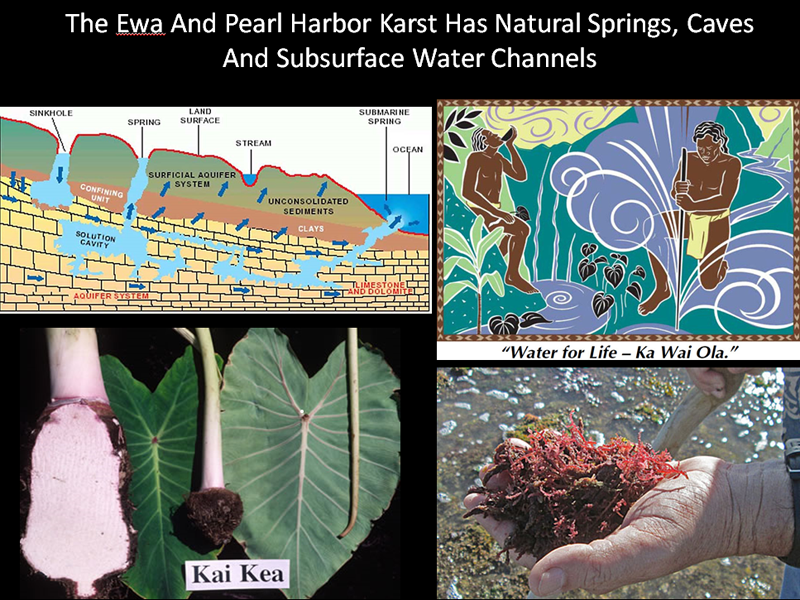
He Wahi Mo‘olelo No Honouliuli, Moku o ‘Ewa — Traditional and Historic Accounts of Honouliuli, District of ‘Ewa (Hoakalei Cultural Foundation – Working Paper) Kepa Maly Kumupono LLC
These excerpts describe the cultural history of the former MCAS Ewa, once known as Kanehili by Pele’s sister goddess Hi‘iaka, also Kualaka’i, the ancient trail and the Kaupe’a lands of the Leina a ka uhane.
Kepa Maly’s especially notable research was done under an FTA-HART TCP (Traditional Cultural Place) contract which did very extensive ethnographic research on the Leina a ka uhane which is shown to cover the NASBP-MCAS Ewa bases and the location of the 1942 Ewa Field West Revetment sites.
The Leina a ka uhane is a Federally recognized cultural landscape district and Traditional Cultural Place. The Leina is identified as on the Plain of Kaupe’a and includes Kanehili. Navy BRAC studies extensively document the Plain of Kaupe’a and Kanehili as including NAS Barbers Point and MCAS Ewa.
Hawaiian goddess Hi‘iaka, sister of Pele, traveled the Ewa Plain and chanted:
Hi‘iaka then turned and continued her walk in the stifling heat of the sun on the plain of Pu‘uokapolei. Hi‘iaka saw a ma‘o blossom as she descended, and she picked it in the heat of the sun and chanted out:
Liua o Kona i ka lā loa o Makali‘i - Kona is made dizzy in the long days of Makali‘i [summer]
Māewa ka wiliwili hele i ka la‘i - The wiliwili [Erythrina] trees sway, then comes the calm
(Wiliwili [Erythrina] trees are still found along the ancient trail route in Kanehili-former MCAS Ewa)
Kulo‘ia ka manu o Kānehili - The birds of Kānehili endure
Welawela ka lā o Pu‘uokapolei - The sun is exceedingly hot on Pu‘uokapolei
‘Ukiki ka ma‘o kula i kai - The ma‘o growth is stunted on the seaward plain
Me he kapa halakea ala ka pua - The nohu [Tribulus cistoides] flowers are o ka nohu - like a halakea [kapa] covering
(Nohu [Tribulus cistoides] ground vine found along the ancient trail route in Kanehili-MCAS Ewa)
Ka ‘owaka, ka pua‘ula i ke kaha - The pua‘ula [young kumu] fish seem
o Kaupe‘a la - to flash along the shores of Kaupe‘a
(The Kanehili area is considered as an ili (subdistrict) of the plain of Kaupe’a)
I ka wiliwili i ka pua o ka lau noni - Where the noni blossoms are twisted together
O ka ihona i Kānehili la- Descending along Kānehili
(Noni - Morinda citrifolia is still found along the ancient trail route in Kanehili-MCAS Ewa)
Ua hili ho‘i au—e - I am winding along
Owau e hele i ke kaha o Pu‘uloa- It is I who travel along the shore of Pu‘uloa
I ka ‘ōhai a Kaupe‘a la- Where the ‘ōhai is at Kaupe‘a
(Ōhai - Sesbania tomentosa is still found along the ancient trail route in Kanehili-MCAS Ewa)
(Kaupe‘a, directly related to the Leina a ka uhane leaping place Leilono. Leinono may also be written as Leilono. It is an area in the midlands of Moanalua above Āliamanu, and is situated near the border of the districts of ‘Ewa and Kona. At Leilono there was a supernatural ulu (breadfruit tree) from which spirits of the deceased leapt and were either caught by welcoming ‘aumākua (ancestral deities) or they would fall into an endless night. From Leinono, the unfortunate spirits are said to have wandered hopelessly across the plain of Kaupe‘a on Honouliuli and gone off into the sunset (Kamakau 1968: 47 & 49).
Descending to the flat lands of Honouliuli, Hi‘iaka then turned and looked at Pu‘uokapolei and Nāwahineokama‘oma‘o who dwelt there in the shelter of the growth of the ‘ōhai [Sesbania tomentosa], upon the hill, and where they were comfortably refreshed by the blowing breezes. Hi‘iaka then said,
“Pu'u O'Kapolei and Nāwahineokama‘oma‘o, -do not forget me, lest you two
go and talk behind my back and without my knowing, so here is my chant
of greeting to you:”
Aloha ‘olua e Pu‘uokapolei mā Greetings to you two o Pu'u O'Kapolei and companion
Lei kaunao’a i ke kaha o Ka‘ōlino is the lei of the shores of Ka‘ōlino.
(Kaunao‘a [Cuscuta sandwichiana] is still found along the ancient trail route in Kanehili-MCAS Ewa)
When Hi‘iaka finished her chant, Pu‘uokapolei said,
“Greetings. Love to you, o Hi‘iaka! So it is that you pass by without visiting the two of us. Lo, we have no food with which to host you. Indeed, the eyes roll dizzily with hunger. So you do not visit us two elderly women who have cultivated the barren and desolate plain. We have planted the ‘uwala [sweet potato]
(uala [Ipomoea batatas - sweet potato] was a major food plant grown along the ancient trails and watered with fresh water from the deep Kanehili sinkholes that carried rain water from the Waianae volcano to the shores of Ewa.)
Hi‘iaka then turned and continued her walk in the stifling heat of the sun
on the plain of Pu‘uokapolei. Hi‘iaka saw a ma‘o blossom as she
descended, and she picked it in the heat of the sun and chanted out
Liua o Kona i ka lā loa o Makali‘i - Kona is made dizzy in the long days of Makali‘i [summer]
Māewa ka wiliwili hele i ka la‘i - The wiliwili [Erythrina] trees sway, then comes the calm
(Ma'o Hawaiian Cotton - Gossypium tomentosum found in dry areas in Kanehili)
Kulo‘ia ka manu o Kānehili - The birds of Kānehili endure
Welawela ka lā o Pu‘uokapolei - The sun is exceedingly hot on Pu‘uokapolei
‘Ukiki ka ma‘o kula i kai - The ma‘o growth is stunted on the seaward plain
Me he kapa halakea ala ka pua - The nohu [Tribulus cistoides] flowers are o
ka nohu like a halakea [kapa] covering
Ka ‘owaka, ka pua‘ula i ke kaha - The pua‘ula [young kumu] fish seem
o Kaupe‘a la- to flash along the shores of Kaupe‘a
When Hi‘iaka finished her chant, she continued toward the shore, and looking to the ocean, she saw the canoe of her friend and Lohi‘au, and chanted:
Ku‘u kāne i ke awa lau o - My man on the many harbored Pu‘uloa sea of Pu‘uloa
Mai ke kula o Pe‘ekāua ke noho- As seen from the plain of Pe‘ekāua
E noho kāua i ke kaha o ka ‘ōhai - Let us dwell upon the ‘ōhai covered shore
I ka wiliwili i ka pua o ka lau noni - Where the noni blossoms are twisted
together
O ka ihona i Kānehili la- Descending along Kānehili
Ua hili ho‘i au—e- I am winding along
Upon finishing her chant, Hi‘iaka continued down the trail and arrived at Kualaka‘i. At Kualaka‘i, the trail took her to a spring of cool water. Looking into the spring, she saw her reflection shining brightly upon the water’s surface. Hi‘iaka also saw two lehua trees [Metrosideros polymorpha – growing on each side of the spring. Now these two lehua trees were completely covered with blossoms. She then picked the lehua blossoms of these two trees and strung garlands for herself.
(Kanehili Cultural Hui believes they have found the original location of the ancient Spring of Hoakalei and advocated that it be made a State and National Register site. There is documentation to support this. It is located just west of the US Coast Guard Barbers Point air station.)

Hi‘iaka strung four strands to her lei, she then removed the garlands of ma‘o which had received when descending from Pōhākea, and set them aside. She then took the garlands which she had made, and adorned herself with them. Hi‘iaka then heard the voice calling out from the area of Kānehili:
O Hi‘iaka ka wahine Hi‘iaka - is the woman
Ke ‘ako la i ka pua o Hoakalei - Who picked the flowers of Hoakalei
Ke kui la, ke uo la i ka mānai - And with a needle strung and made them into
‘Ehā ka lei, ka ‘āpana lei lehua - Four garlands, the sectioned lei
a ka wahine la - of the woman
Ku‘u pōki‘i O - my younger sibling
Ku‘u pōki‘i mai ke ehu makani - My younger sibling who came from
o lalo the place where the dusty wind rises from below
Lulumi aku la i ke kai o Hilo-one - Overturned in the sea of Hilo-one
No Hilo ke aloha - The aloha is for Hilo
Aloha wale ka lei e— Love for the lei
That place, Hilo-one, which is mentioned in the mele [chant], is situated on the northern side of Kualaka‘i. And the name of the spring in which Hi‘iaka looked and saw her reflection was Hoakalei [Reflection of a lei]. It was at this place that Hi‘iaka saw the two lehua trees growing, from which she picked the blossoms to string her four garlands.
The reason that Hi‘iaka presented this chant to her elder sister Kapo, saying, “kui pua lei, o Hoakalei” [Stringing flower garlands of Hoakalei] was because in her chant, Kapo had inquired about Hi‘iaka’s picking the flowers from the spring of Hoakalei and making them into four garlands for herself... As it is seen in this mele [chant], Hilo-one is on O‘ahu, there at Kualaka‘i, near Kalaeloa (ancient Kanehili.)
Thus it is understood that through legends like this, we are given direction in knowing about the names of various places of the ancient people, and which are no longer known in this time...Hi‘iaka then continued her journey toward the shore of Pu‘uloa, and she thought about the words that she had earlier spoken to Wahine‘ōma‘o and Lohi‘au, and she chanted:
A‘ole au e hele i ke kaha o- I will not travel to the shore of Kaupe‘a Kaupe‘a
I nā ‘ōhai o Kānehili i Kaupe‘a - To Kaupe‘a where the ‘ōhai of Kānehili are found
A ua hili au... - I will turn away...
In this chant of Hi‘iaka, she spoke the famous saying that is the pride of the descendants of ‘Ewa; “Ke one kui-lima laulā o ‘Ewa” [The sands of ‘Ewa, across which everyone joined hand-in-hand]. These words of Hi‘iaka are a famous saying of this land to this day.
Tuggles Survey Report, NASBP-MCAS Ewa, Navy BRAC 1997-99


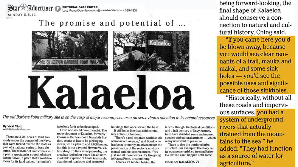
2013 Star-Advertiser feature quotes HCDA administrator Tony Ching that there really were “underground rivers- from mountains to the sea” and functioned as a “source of water for agriculture.” Fo many years the Navy and Army Corps of Engineers had denied that there was such a thing as karst caves and ponds which were actually connected by tidal flows. Navy in their Hunt Corp KREP PV project Programmatic Agreements (PA) insisted this was just- “a belief by some Hawaiians” including that water feeding limu growth- “just a belief by some Hawaiians.”

Huge underwater freshwater spring off Ewa shore near Kualakai’i. Likely why there was once the popular Kualaka’I fishing village and why the 1825 Malden native Hawaiian trail went there. Fresh underwater springs are major attractants for large sea life ecosystems and help limu spawn. Oral histories tell of once bountiful quantities of easily harvested fisheries, from shellfish to pelagic.
The Enduring Song of Uncle Henry Chang Wo Jr.
https://www.civilbeat.org/2015/10/the-enduring-song-of-uncle-henry-chang-wo-jr/
Uncle Henry used to say: “We watch that first raindrop that hits the island. We follow the raindrop all the way to the ocean, we don’t let that raindrop get dirty. Because when that mountain water and that ocean water meet, when they come together that’s when the ocean hānau, that’s when the ocean gives birth. Our fishes depend on that, the estuary, they all need that water from the mountain. If it was only the ocean itself, too salty, she make (dies) and that is what is happening now.”
‘ŌLELO NO‘EAU
https://www.lokoea.org/uploads/1/1/3/4/113439871/olelo_noeau.pdf
Selected Historic References to the ‘Ewa-Honouliuli Region
He Wahi Mo‘olelo No Honouliuli, Moku o ‘Ewa — Traditional and Historic Accounts of Honouliuli, District of ‘Ewa (Hoakalei Cultural Foundation – Working Paper) Kepa Maly Kumu Pono LLC
Kanehili Wandering Spirits
The coastal coral plains of Honouliuli, which stretch behind Kualaka‘i, Keahi, and One‘ula (the HART RAIL project area), are thought to be the legendary “kula o Kaupe‘a” (plain of Kaupe‘a) which is said to be the realm of the ao kuewa or ao ‘auwana (the homeless or wandering souls). Kaupe‘a was the wandering place of those who died having no rightful place to go; the souls wandered “in the wiliwili grove” (Sterling and Summers 1978:36).
According to 19th century Hawaiian historian Samuel Kamakau, the spirits who wandered “on the plain of Kaupe‘a beside Pu’uloa...could go to catch pulelehua (moths or butterflies) and nanana (spiders)” in the hope of finding helpful ‘aumakua (family deity) who could save them (Kamakau 1964:47 and 49).
Recollections of Mary Kawena Pukui - Hawaiian ethnographer
One of the native Hawaiian informants who recorded her recollections of the Ewa Honouliuli area was Hawaiian ethnographer and Bishop Museum employee, Mary Kawena Pukui. Pukui shared her personal experience with the ghosts on the plain of Kaupe‘a around 1910:
A wide plain lies back of Keahi and Pu‘uloa where the homeless, friendless ghosts were said to wander about. These were the ghosts of people who were not found by their family ‘aumakua or gods and taken
home with them, or had not found the leaping places where they could leap into the nether world. Here [on the plain of Honouliuli] they wandered, living on the moths and spiders they caught. They were often very hungry because it was not easy to find moths or to catch them when found.
Perhaps I would never have been told of the plain of homeless ghosts if my cousin’s dog had not fainted there one day. My cousin, my aunt and I were walking to Kalae-loa, Barber’s Point, from Pu‘uloa accompanied by Teto, the dog. She was a native dog, not the so-called poi dog of today, with upright ears and body and size of a fox terrier. For no accountable reason, Teto fell into a faint and lay still. My aunt exclaimed and sent me to fetch sea water at once which she sprinkled over the dog saying,
“Mai hana ino wale ‘oukou i ka holoholona a ke kaikamahine. Uoki ko ‘oukou makemake ‘ilio.” “Do not harm the girl’s dog. Stop your desire to have it.” Then with a prayer to her aumakua for help she rubbed the dog. It revived quickly and, after being carried a short way, was as frisky and lively as ever. Then it was that my aunt told me of the homeless ghosts and declared that some of them must have wanted Teto that day because she was a real native dog, the kind that were roasted and eaten long before foreigners ever came to our shores (Pukui 1943:60-61).
Kanehili Kiawe Forests, Fishing Shanties, Karst Water Ponds
In 1898, Cameron (1898) noted that the kiawe forests of ‘Ewa supplied much of the fuel for kitchen fires in Honolulu. Harvesting of kiawe wood continues to this day, although not on the scale that was undertaken during Cameron’s time. Earlier this century, a few fishermen and some of their families built shanties by the Ewa shore where they lived, fished, and traded their catch for taro at ‘Ewa (see also the interview notes below with Mrs. Arline Eaton; March 4, 1997). Their drinking water was taken from nearby ponds, and it was so brackish that other people could not stand to drink it.
Kanehili Opae Ula Shrimp - Halocaridina rubra in deep sinkholes
There are 1930’s photos of Ewa Villagers in small sampans collecting Opae Ula Shrimp at Ordy Pond

OR&L train stop near the old Ewa sisal plantation gave access to the ancient Kualaka’i trail for local families before WW-II closed off the entire area for fishing, limu picking and fresh lobster
The family of the late Eli Williamson (former Bishop Museum staff member and companion of Hawaiian ethnographer, Mary Kawena Pukui, cited above), lived in the small community at Kualaka‘i. Kelly (1985) reported on some recollections:
Mrs. Williamson:
In the Honouliuli area the train stopped among the kiawe (algaroba) trees and malina (sisal) thickets. We disembarked with the assorted food bundles and water containers. Some of the Kualaka‘i ‘ohana met us to help carry the ‘ukana (bundles) along a sandstone pathway (the ancient Kanehili Kualaka’I trail) through the kiawe and malina. The distance to the frame house near the shore seemed long. When we departed our ‘ukana contained fresh lobsters, limu (algae), fish and i‘a malo‘o (dried fish)....Tutu mā (grandfolks and others) shared and ate the seafoods with great relish. (E. Williamson in Kelly 1985:160)
Arline Wainaha Pu‘ulei Brede-Eaton Informal Oral History Interview—lands of Pu‘uloa-Honouliuli with Kepā Maly, March 4, 1976
The following information is a paraphrased summary of historical recollections collected during an informal interview with Arline Wainaha Pu‘ulei Brede-Eaton (Aunty Arline). The information was collected as a part of the effort to develop a site preservation plan in conjunction with proposed development on a parcel of property on the ‘Ewa plain, in the land of Honouliuli (see also the interview with Sister Parish and Aunty Arline, of May 2, 1997). The property is generally situated on the coastal
flats, between One‘ula and Kualaka‘i, and while the area has been impacted by cattle ranching and WWII military operations, a number of native Hawaiian cultural sites still remain on the property.

ABOVE – Puuloa (Pearl Harbor) in 1890. Incredible shell fish filled lagoons, mullet fishponds, karst sea caves with large protective pet sharks that Ewa residents could ride like horses.
Born in 1927, Aunty Arline has lived in Pu‘uloa nearly all of her life. Aunty’s hānai (adoptive) parents had been going to the Pu‘uloa vicinity for years—Papa Brede oversaw ranch operations for the Dowsett’s—and by the time Aunty was born, had bought land and built a home at Pu‘uloa. Initially the family spent weekends and holidays at Pu‘uloa, living in Kalihi on weekdays. Aunty observed that many of her earliest memories are of her days at Pu‘uloa, and today, she is one of the oldest long-time native Hawaiian residents remaining on the land.
In those early days, Aunty recalls that they were among the few families living in the area. Besides her family, Dowsett Ranch had about 12 cowboys, all Hawaiians, and their families. Few other people lived in the area. When asked about her recollections of life and activities in those early years, Aunty Arline shared the following memories:
The whole region was our playground, we’d go to Keahi, go by canoe to Laulaunui and fish, and in the other direction, we’d walk as far as Kalaeloa. (Laulaunui Island is in West Loch and location of rich fisheries of pre-western Honouliuli .)
As children, we’d never think twice about walking anywhere, the distance was nothing. We would walk from Pu‘uloa to the shore at (Ke) One‘ula, and then on to Kualaka‘i, and along the way we would gather limu (sea-weed). There was limu kohu, līpoa, and ‘ele‘ele, and the fish were so plentiful, not like now.
We’d catch ‘ō‘io, kala, weke, moana, ‘ū‘ū, and all kinds of fish. It was a good place. Back when I was a child, there was more sand also, the entire shore line was like the beach at Barbers Point. Today, the shore line has all of that craggy coral, before it had sand between the coral and the water. Things have
changed now, I don’t know why. (A lot of sand was taken for construction projects, filling sinkholes.)
While no one was living full time out between Keone‘ula and Kualaka‘i, there were families that would come out for several months at a time. Sort of like my dad them, they’d work in town or somewhere else, and set up temporary residence on the beach. They didn’t own the land, but they would go out and
stay for certain periods of time. The people would fish, gather limu, and make pa‘akai (salt). Other than that though, there was no one living out here. There was not much activity in the area behind the shore. I don’t remember that there were cattle back there, and the sugar ended further inland. The CPC (California Packing Co -Del Monte’s predecessor) had a camp down by Keone‘ula, and from there, there was an old piggery and the old chicken farm. The chicken farm was run from around the early 1930s to 1970. (The Ewa Plantation eventually took over the CPC beach facility for employee recreation and was later known as Hau Bush, also the site of Dec 7, 1941 Pearl Harbor eyewitness Ramsay Hishinuma.)
Kepa Maly: When you’d go out into the area of the proposed Haseko development, did you ever hear your parents or any of the old cowboys speak about Hawaiian sites or any stories in the area?
Arline Eaton: I don’t remember hearing too much about any of the history in the area, but I do remember being told that there were some heiau in the area. I think that site (Site 3209) in the Haseko property, the one that will be included in the preservation plan, the coral stone platform is one of the heiau sites. I remember being told that the heiau in this area were good heiau, the kind used for fishing, rain, and agriculture.
KM: Where did people get water from when they were out there?
AE: There’s water out there, it's wai kai (brackish), but we were used to that water, not like today. You can tell that there’s water there along the shore, you can see it bubbling up, and the limu ‘ele‘ele will only grow where there is fresh water coming out of the papa (reef flats). And you know, when Iwas young, there was a lot more water in the ponds back there. People don’t believe me, but I remember when I was a child, there was a lot of water there.
KM: Do you remember the wetlands?
AE: Yes. That’s the place where Captain Kealaka‘i’s mo‘opuna (grandson) and I would go play. The water went far across the flats there. If I’m not mistaking, I think it went all the way behind the Barbers Point beach area. The place was clean too, not like now. There were no kūkūs (thorns), and used to have plenty manu (birds). We’d go swim in the ponds back there, it was pretty deep, about two feet, and the birds were all around. There were kōloa (native ducks) and āe‘o (native stilts), and people don’t believe
this, but there were also ‘iwa (frigate birds). I remember that when they were nesting, I would see their red chests puff out. It seems like when there were storms out on the ocean, we’d see them come intothe shore, but they’re not around any more. The wetland would get bigger when there was a lot of rain, and we had so much fun in there, but now the water has nearly all dried up. They even used to grow wet-land taro in the field behind the elementary school area when I was young.
Another interview:
KM: Do you remember what the grazing material was then, down here that made a good fattening ground?
TGP: I guess the kiawe beans.
KM: So just the kiawe beans?
TGP: Kiawe beans and the haole koa.
KM: Hmm. Was that the predominant growth throughout the Kūpaka-Pu‘uloa, even into here, Honouliuli area?
TGP: Yes. Oh yes. It was primarily kiawe, the algaroba, and pā-nini, the klu bushes and the cactus, the haole koa, lots of it.
Cannery Tales: Community Leaders Talk Story About Bygone Summers in Honolulu’s Pineapple Factories
https://www.honolulumagazine.com/cannery-tales-community-leaders-talk-story-about-bygone-summers-in-honolulus-pineapple-factories/ (Ewa historian John Bond worked as a Dole tray boy)
Ramsay Hishinuma, at Hau Bush Dec 7, 1941. PH Attack Eye Witness, Part One of Two
https://www.youtube.com/watch?v=JMAH0wsZds8
WWII Japanese Air Crew Buried Under Ewa Beach Hawaii Golf Course
http://4ewanews.blogspot.com/2014/11/japanese-buried-air-crash.html
REFERENCES CITED
Cameron, W. l898 Trip on Oahu Railroad. Paradise of the Pacific. Honolulu.
Kamakau, S.M. (M.K. Pukui, translator) 1964 Ka Po‘e Kahiko: The People of Old. B.P. Bishop Museum Special Publication 51. Bishop Museum Press, Honolulu.
Kelly, M. 1985 Notes on the History of Honouliuli. Appendix A IN: An Archaeological Survey
of the Naval Air Station, Barber’s Point O‘ahu, Hawai‘i. A.E. Haun, Project Director. Department of Anthropology, B.P. Bishop Museum, Honolulu. Prepared for Commander, Pacific Division Naval Facilities Engineering Command, Pearl Harbor, Hawai‘i. Contract No. N62742-84-R-0075.
Lewis, E. 1970 The Campbell Project: A Preliminary Report. University of Hawaii, Appendix
C, IN W. Barrera (1975b). McAllister, J.G. 1933 Archaeology of Oahu. B.P. Bishop Museum Bulletin 104. B.P. Bishop Museum Press.
Pukui, M.K.1943 Ke Awa Lau o Pu‘uloa: The many-harbored Sea of Pu‘uloa. Hawaiian Historical Society Report 52:56-62. Honolulu. Sterling, E.P., and C.C. Summers 1978 Sites of Oahu. Department of Anthropology and Education, B.P. Bishop Museum.

This amazing Malden map shows the Ewa Plain cultural landscape from Pu’u-o-Kapolei to the Leina a ka uhane spirit leaping place of Leilono on Aliamanu crater overlooking Pearl Harbor
MOANALUA AHUPUA‘A – Hi’iaka, Aliamanu, Leilono (the Leina a ka uhane leaping place)
A pet bird of Hi‘iaka’s gave the name to Āliamanu
https://www.ksbe.edu/assets/site/special_section/regions/ewa/Halau_o_Puuloa_Moanalua.pdf
One of the most sacred wahi pana in Moanalua, Leilono, once located along the upper rim of the
Āliamanu crater, was an entrance to Pō, or the “otherworld.” Samuel Kamakau published several
versions of this mo‘olelo. The following is a translation of Kamakua’s writings from the original
Hawaiian newspaper, Kuokoa (August 11, 1899):
LEILONO: It was a place said to be the opening, on the island of Oahu, for mankind to enter eternal night.

This place is on the northern side of the famous hill of Kapukaki (now Red Hill), at the boundary of Kona and Ewa, right in line with the burial hill of Aliamanu, on the upper side of the old road. It is said that this place [Leilono] is round, about two feet or more in circumference. This is the hole through which the ghosts of people slipped through to go down and this was the strata of Papa-ia-Laka. Through this opening appeared the supernatural branches of the breadfruit of Leiwalo. If a ghost who lacked an aumakua to save him climbed on a branch of the western side of the breadfruit tree, the branch
withered at once and broke off, thus plunging the ghost down to the pit of darkness. The boundaries of this place, so the ancients said, were these: Papa-kolea which was guarded by a plover; Koleana whose guard was a big caterpillar and Napeha, the western boundary which was guarded by a lizard. (Sterling and Summers 1978:9) (brackets added
Hawaiians believed Āliapa‘akai was “bottomless” and connected with the ocean; Pele tried to dig a dry cave here and struck salt water (Rice 1923); Pele and Hi‘iaka dug into the ground to make a home at Āliapa‘akai (Fornander 1916-1920); a pet bird of Hi‘iaka’s gave the name to Āliamanu.
Hawaiian Cultural History of Honouliuli Ahupuaʻa
Honouliuli Ahupuaʻa - A history of the largest land division on Hawaiʻi's island of Oʻahu http://www.hoakaleifoundation.org/timeline
Honouliuli Ahupuaʻa (arcgis.com)
McIntosh and Cleghorn, 1999, Archaeological archival research report Honouliuli Wastewater Treatment Plant determined little likelihood of encountering surface resources, but subsurface resources in form of sinkholes or burials possible. The soil was only about 1 m deep over a coral substrate.
E ka manu o Kanehili - By the bird of Kanehili. Kanehili – MCAS Ewa area was known as a place to catch o’o birds without harming them. Specific bright yellow feathers were plucked for royal capes. Then the birds were released. Moho is a genus of extinct birds in the Hawaiian bird family, Mohoidae, that were endemic to the Hawaiian Islands. Members of the genus are known as ʻōʻō in the Hawaiian language. Their plumage was generally striking glossy black; some species had yellowish axillary tufts and other black outer feathers. Hawaiʻi ʻōʻō - Wikipedia
Kanehili First Ulu - Breadfruit Tree Brought To Oahu
Ka‘uluakāha‘i (The Breadfruit Tree of Kāha‘i) at Kuālaka‘i | Hoakalei Cultural Foundation (hoakaleifoundation.org)
Ka‘uluokaha‘I - Kualaka‘i as the place where the first ‘ulu (breadfruit) tree planted
https://dhhl.hawaii.gov/wp-content/uploads/2014/07/140730-EKapIIB-Program.pdf
Kualaka‘i - An ancient place name of a community located at a place today known as Nimitz Beach in Kalaeloa. Mo‘olelo (ancient stories) identify Kualaka‘i as the place where the first ‘ulu (breadfruit) tree was planted by a Tahitian chief by the name of Kaha‘i. Nā mo‘olelo refers to Kaha‘i leaving ‘Oahu and traveling to Sāmoa where he finds the ulu tree and returns to O‘ahu by way of Kahiki (Tahiti). Kualaka‘i gets its name from a corruption of “Ka ‘Ulu O Kaha‘i,” “The ‘Ulu tree of Kaha‘i.”
There was once a large community of people who lived in Kualaka‘i prior to western contact as evidenced by archaeological finds.
At the OR&L train stop (likely the old sisal plantation platform) passengers could mount horses guided by local paniolo cowboys who would take them down the ancient Kualaka’i trail to the Kualaka‘i shore and purchase fresh fish, limu and lobster to take back on the train to Honolulu.

State of Hawaii tax records indicate that a number of people who lived at Kualaka‘i were paying taxes between 1855 and 1877. During the period up to 1930, people were riding the train from Honolulu to Kualaka‘i to purchase fresh fish, limu lipoa, crab and lobster. They would get off the train in the area of the former Barbers Point Naval Air Station (likely the old sisal plantation railway stop.) They would then get on horses guided by paniolo cowboys who would take them to Kualaka‘i, where in 1930 only one house stood. The owners of the house were a Hawaiian family who made their living catching fish, limu and lobster to sell to visiting Honolulu town families.
Kaha‘i - A Tahitian chief credited for planting the first ‘ulu (breadfruit) tree in Hawai‘i at a place known as Kualaka‘i, (today known as Nimitz Beach.)
Kaupe‘a - was the navigation point for canoes to travel to and from Tahiti by using the Hānaiakamālama (Southern Cross) constellation as the waypoint to travel south.
Kaha‘i was the Tahitian chief who landed at Kualaka‘i by the use of the Kaupe‘a waypoint
The Plains of Kaupe‘a, Pu‘uokapolei, and the Realm of Homeless Souls
A highly documented Traditional Cultural Place (TCP) officially identified under a federal contract for HART RAIL yet today Navy, HCDA, Hunt Corp, DLNR, etc all REFUSE TO HONOR THIS RECOGNITION!
There are several places on the ‘Ewa coastal plain associated with ao kuewa, the realm of the homeless souls. Samuel Kamakau (1991b:47-49) explains Hawaiian beliefs in the afterlife: There were three realms (ao) for the spirits of the dead. . . . There was, first, the realm of the homeless souls, the ao kuewa; second, the realm of the ancestral spirits, the ao ‘aumakua; and third, the realm of Milu, ke ao o Milu . . . [Kamakau 1991b:47-49]
This association of Pu‘uokapolei and Kānehili with wandering souls is also illustrated in a lament on the death of Kahahana, the paramount chief of Oahu, who was killed by his foster father, the Maui chief Kahekili, after Kahahana became treacherous and killed the high priest Ka‘opulupulu.
E newa ai o hea make i ka la, - Go carefully lest you fall dead in the sun,
Akua noho la i Puuokapolei. - The god that dwells on Kapolei hill
E hanehane mai ana ka la i na - The sun is wailing on account of the
wahine o Kamao, - women of Kamao,
Akua pee, - A hiding god, blossoming
pua ohai o ke kaha, - ohai of the banks,
I walea wale i ke a- - Contented among the stones—
I ka ulu kanu a Kahai. - Among the breadfruit planted by Kahai.
Haina oe e ka oo— Thou wast spoken of by the oo—
E ka manu o Kanehili.- By the bird of Kanehili.
[Fornander 1919:6(2):297]
Fornander provides some notes on this lament. The god dwelling at Kapolei is Kahahana, stating that this is where his soul has gone. Kamao is one of the names of the doors to the underworld. This lament draws an association with wandering souls and the place where the first breadfruit tree was planted by Kaha‘i at Pu‘uloa (Fornander 1919:6(2):304). Some stories say that the first breadfruit tree was planted at Kualaka’i (near Nimitz Beach area, by the US Coast Guard Station Barbers Point,) while other accounts say it was Puuloa. The USCG base west area is where the legendary Spring of Hoakalei exists.
Kanehili is associated as an ili (sub district) mauka - below the larger plain of Kaupe’a generally in the center of the larger Ewa Plain area. Above Kaupe’a would be Pu’u-o-kapolei.
Pukui (1983:180) offers this Hawaiian saying, which places the wandering souls in a wiliwili grove at Kaupe‘a. Ka wiliwili of Kaupe‘a - The wiliwili grove of Kaupe‘a. In ‘Ewa, O‘ahu. Said to be where homeless ghosts wander among the trees. The Kanehili – MCAS Ewa area still has the largest concentration of remaining wiliwili trees on the Ewa Plain which adds to the historic integrity of Kanehili’s association with the Kepa Maly TCP documented Leina a ka uhane and the soul’s leaping place from Leiolono – Aliamanu.
Kūalaka'i is the name of an ancient village where a supernatural 'ulu (breadfruit) tree was planted by Ka'uluakāha'i (a deified navigator). He would leave gifts at the tree for his son Nāmakaokapāo'o. This was also where Hiʻiaka-i-ka-poli-o-Pele (Hiʻiaka in the bosom of Pele )wove her own lei from lehua blossoms, and where she saw her reflection in a spring stream, which she then named Hoakalei (reflection of a lei). Kanehili Cultural Hui’s research locates the Hoakalei spring as being at the end of the now closed Coral Sea Road – Nimitz Beach on the west side of the USCG Station Barbers Point.

LEILONO is a REAL PLACE and a key TCP of the Leina a ka uhane
The Federal Transit Administration decided the rail route and stations would not interfere with the very important sacred flight vector for departing native spirits called the Leina a ka 'uhane. The pathway very conveniently begins just south of the East Kapolei station track end point. TCP maps show the soul’s leaping place is from Leiolono – Aliamanu. However it was determined by FTA-HART that the pathway just missed being in the area of the KROC railway station and instead was located in former NASBP and MCAS Ewa.

FTA and HART Decide Sacred Hawaiian Spirit World Starts At End Of East Kapolei Rail Station (so perfect and precise!)
http://honouliuli.blogspot.com/2015/01/leina-ka-uhane-wahi-pana.html
West Oahu Leina A Ka Uhane Spirit Pathway Recognized By Federal Transit Administration
http://honouliuli.blogspot.com/2015/07/Leina-a-ka-uhane.html
2011 CIA: 1825 Malden native Hawaiian trails in Kanehili-MCAS Ewa
These excerpts from the 2011 Ka Makana Alii Mall Cultural Inventory Survey (CIA) by Pacific Legacy describe the Kualaka’i trail, the ancient native Hawaiian trail that once ran through the Ka Makana Alii Mall site linked to Honouliuli. The CIA supports the Tuggles Navy BRAC map which shows the Kualaka’Ii trail crossing Franklin D. Roosevelt Avenue and then enters directly mauka-north of the 1942 Ewa Field West Aircraft Revetments and 1944 air transport parking ramp and then running Makai – south through this same site area and to Kualaka’i.

Based on terrain and availability of water, the ‘Ewa Plain can be separated into three main geographical regions that are described by Tuggle and Tomonori-Tuggle (1997:9) as: “lowland limestone exposure, the upland alluvial terrain, and a locale of floodplain and alluvial fans.”
Fresh water on the barren coral plain has often been reported as being insufficient to support a permanent or substantial Hawaiian settlement during pre-Contact years. However, Tuggle and Tomonari-Tuggle (1997:18-21) summarize various research projects on the availability of water in ‘Ewa Plain asserting that there may have been permanent Hawaiian settlements in a number of locales, if not generally across the entire area. Water sources were identified in several locations on the plain, including sinkholes that reach the water-table, wetlands, sheet runoff, spring and creek water from gulches, natural limestone water traps, Honouliuli Stream, and other water features in Honouliuli Ahupua‘a (Malden 1825).
The ‘Ewa Plain gently slopes mauka or towards the mountains, due to the deposition of alluvial clays and silts that are derived from weathered basalt from upslope. The alluvial substrate forms a wedge that lies atop the limestone bench, itself positioned above the basalt foundation (Geolabs-Hawaii 1987; Stearns and Vaksvik 1935). This limestone shelf contains artesian basal aquifers that are the source of potable water found in springs and wells in several locations across the plains; two of the most prominent locations, Honouliuli Gulch ``Watering Place” and Waihuna in Kalo‘i Gulch, are within two miles of the project area (Malden 1825; Sterling and Summers 1978; Mooney and Cleghorn 2008c).
HONOULIULI AHUPUA‘A IN THE EARLY TO MID-1800S
The ‘Ewa Plain was described as a near uninhabitable place in early accounts, however, Honouliuli Village was viewed more as an oasis with a sizable population, aquatic abundance, and burgeoning agricultural system. As seen in the Land Commission Award’s Native Testimonies and early maps of Honouliuli, land adjacent to West Loch was intensively farmed with a variety of traditional agricultural methods from early Contact times into the late 1800’s (Dicks et al. 1987, Appendix A; Malden 1825; Monsarrat 1878.
The coastal areas were also famous for their marine resources and inland fishponds, as evident in oral and written history. Connecting Honouliuli Village and the trail leading from Honolulu to Waianae was a trail, often referred to as Kualaka‘i Trail, which appears in the Malden 1825 map of the south coast of Oahu.The ancient trail leads from Honouliuli Village to Keoneula (Hau Bush) with a leg leading to Kualaka‘i.
Edwin Hall, Hawaiian Minister of Finance, described west ‘Ewa as a “barren, desolate plain” in the early 1800s after traversing much of the island of Oahu (Hall 1839 as quoted in Lewis 1970: Yet, according to maps of the early to late 1800s (Malden 1825; Monsarrat 1878; Honouliuli was labeled as the “Watering Place” and depicted as a relatively large agricultural community. Honouliuli Village had an abundance of natural resources, such as rich soil, marine life, and fresh water since pre-Contact times as depicted by early maps. and written accounts (A. Campbell 1819; Chamberlain Ms.; Kamakau 1991). These vital elements permitted the development of an extensive system of irrigated taro patches or lo‘i as well as landlocked and shoreline fishponds previous to the drilling of the first artesian well commissioned by James Campbell in 1879.
Captain George Vancouver described the ‘Ewa plain as deficient in people and fertility, but said he was informed that inland “…a little distance from the sea, the soil is rich, and all necessaries of life are abundantly produced…” (Vancouver 1798, Vol 3: 361-363). Archibald Campbell later writes of his experience traveling through ‘Ewa in his 1809 essay, “Voyage Round the World,” by stating:
We passed by foot-paths winding through an extensive and fertile plain, the whole of which is in the highest state of cultivation. Every stream was carefully embanked to supply water for the taro beds. Where there was no water, the land was under crops of yams and sweet potatoes. The roads and the sides of the mountains were covered with wood to a great height. We halted two or three times, and were treated by the natives with the utmost hospitality (A. Campbell 1819: 145).
Maps from early to mid-1800s depict Honouliuli as having extensive agricultural fields and fishponds (Malden 1825, Monsarrat 1878.) Additionally, Native Testimony given at the time of the Mahele ‘Āina in 1848, list scores of taro patches (lo‘i kalo), vegetable plots (māla), fishponds (loko i‘a), pig pens (pā pua‘a), pastures (kula), hala groves (ulu hala), and house sites within Honouliuli Valley (Dicks et al. 1987: Appendix A and B).
Tuggle and Tomonari, Tuggle 1997 Phase I archaeological survey Naval Air Station Barbers Point Documented new and previously identified traditional Hawaiian habitation, agriculture, burial, trails, historic ranch sites, and U.S. military sites. Paleontological data recovered from limestone pits.
SIHP -05093 through -05307. Medrano et al. 2014 Coastal parcel bounded by Coral Sea Rd on the East, Documented traditional Hawaiian habitation, agriculture, possible burials, trails, and U.S. military sites. SIHP -05119, -05120, -07483, -07994, -07946 through -07504. Haun 1991; Tuggle and Tomonari-Tuggle 1997; Beardsley 2001, Hawaiian habitation agriculture complex, Walls, enclosures, platform, trail, modified pits.
Solar Energy Fund II (ASEF) facility Archaeological Inventory Survey (AIS 2014)
The survey identified 21 sites interpreted as traditional Hawaiian, post-Contact ranching and 20th-century US military training (Medrano 2014:240).
The traditional Hawaiian features (e.g., enclosures, walls, platforms, mounds, and limestone pits termed karst pits) were interpreted as habitation, agricultural, storage, trails, and possible burials (Medrano et al. 2014:240–246). The possible burial mounds were included in a Burial Treatment Plan (Kingsbury
et al. 2017) and, along with most of the traditional Hawaiian sites, were avoided and placed under protective preservation (Hazlett 2020). Two sites (SIHP 50-80-12-07487 and -07502) were recommended for data recovery and archaeological monitoring was required during all construction activities. Of interest, a northeast–southwest trending trail (SIHP 50-80-12-07457, Feature 1) was recorded in the project area that may have extended near or across Parcel 40 of the current study area.


KANEHILI CULTURAL AND ARCHEOLOGICAL REFERENCES
2001 Identification of Native Hawaiian Traditional Cultural Properties, Navy Region Hawaii. Prepared for the Department of the Navy. International Archaeological Research Institute, Inc.
1999 Cultural Resource Management Plan: Naval Air Station, Barbers Point. Prepared for Department of the Navy, Pearl Harbor, Hawaii under contract with Belt Collins Hawaii, Honolulu, Hawaii. International Archaeological Research Institute, Inc., Honolulu.
1997 (Tuggle, J.S. Athens, J. Ward, and David Welch) Environment, Vegetation Change, and Early Human Settlement on the ‘Ewa Plain: A Cultural Resource Inventory of Naval Air Station, Barbers Point, O‘ahu, Hawai‘i. Part III: Paleoenvironmental Investigations. Prepared for Belt Collins Hawaii. International Archaeological Research Institute, Inc., Honolulu.
1997 The ‘Ewa Plain. Hawaiian Archaeology 6:8-36.
1997 Synthesis of Cultural Resource Studies of the ‘Ewa Plain, O‘ahu. Prepared for Belt Collins Hawaii and the U.S. Navy. International Archaeological Research Institute, Inc., Honolulu.
1996 (Tuggle, S. Wickler) A Cultural Resource Inventory of Naval Air Station, Barbers Point, O‘ahu, Hawai‘i; Part II: Phase II Inventory Survey of Selected Sites. Task 2b: Archaeological Research Services for the Proposed Cleanup, Disposal and Reuse of Naval Air Station, Barbers Point, O`ahu, Hawai`i . Prepared for Belt Collins Hawaii. International Archaeological Research Institute, Inc.
1996 Cultural Resource Management Plan: Naval Air Station, Barbers Point, O‘ahu, Hawai‘i. Task 3d: Archaeological Research Services for the Proposed Cleanup, Disposal, and Reuse of Naval Air Station, Barbers Point, O‘ahu, Hawai‘i. Prepared for Belt Collins Hawaii. International Archaeological Research Institute, Inc.
1995 Archaeological Inventory Survey for Construction Projects at Naval Air Station, Barbers Point, O`ahu, Hawai`i. Prepared for Belt Collins Hawaii and the U.S. Navy. International Archaeological Research Institute, Inc., Honolulu.
Other REFERENCES CITED
Akana, C.L. and K. Gonzalez 2015 Hānau ka Ua Hawaiian Rain Names. Kamehameha Publishing, Honolulu.
Alexander, W.D. 1890 A Brief History of Land Titles in the Hawaiian Kingdom. In Hawaiian Almanac and
Annual for 1891, edited by T. G. Thrum. Press Publishing Company Print, Honolulu.
Allen, J. 1995 Geology, soils, and sediments at Barbers Point, O‘ahu. Archaeological and
Paleontological Investigations at Barber's Point Deep Draft Harbor, Ewa District, Honouliuli Ahupua‘a, Oahu Island, Hawai‘i.
Volume 1: Archaeology and Paleoecology at Barber’s Point. Prepared by the Department of Anthropology, Bernice Pauahi Bishop Museum for Department of the Army, Pacific Ocean Division,
Corps of Engineers. Copy on file at SHPD Library, Kapolei.
Athens, J.S., D. Tuggle, J.V. Ward, and D.J. Welch 2002 Avifaunal Extinctions, Vegetation Change, and Polynesian Impacts in Prehistoric Hawaii. Archaeology in Oceania, 37(2), 57–78. Retrieved January 5, 2021, from http://www.jstor.org/stable/40387214
Beardsley, F.2001 Phase II – Intensive Survey and Testing, Naval Air Station Barbers Point, Land of
Honouliuli, ‘Ewa District, Island of Oahu, Contract No. N62742-93-D-0502, Delivery Orders No. 7 and No. 19. Prepared by Paul H. Rosendahl, Ph.D., Inc. for Commander Pacific Division, Naval Facilities Engineering Command, Pearl Harbor.
Bishop, A.1854 Ewa Station Reports for 1854. Microfilm at Hawaiian Mission Children’s Museum,
Honolulu.Campbell, The Estate of James 2003 James Campbell Esq. Electric Pencil.
Campbell, S.M.1994 Register of the Ewa Plantation Company, Ewa, Oahu, 1891–1960. Processed by
S.M. Campbell. Hawaiian Sugar Planters’ Association Plantation Archives, University of Hawai‘i at Mānoa Library – Hawaiian Collection. https://www2.hawaii.edu/~speccoll/p_ewa.html
Cordy, R. 2002 The Rise and Fall of the O‘ahu Kingdom. Mutual Publishing, Honolulu.
Coulter, J.W. 1935 A Gazetteer of the Territory of Hawaii. Compiled by J.W. Coulter. University of
Hawaii Research Publications No. 11. University of Hawaii, Honolulu.
Davis, B.D. 1995 Archaeological and Paleontological Investigations at the Barber’s Point Deep Draft
Harbor, ‘Ewa District, Honouliuli Ahupua‘a, Oahu Island, Hawai‘i.
Volume 1: Archaeology and Paleoecology at Barber’s Point. Prepared by the Department of
Anthropology, B.P. Bishop Museum for Department of the Army, Pacific Ocean Division, Corps of Engineers. Copy on file at SHPD Library, Kapolei.
1979a Progress Report on Emergency Excavations at Barbers Point, O‘ahu: First Quarter
(January–March), 1979. University of Hawai‘i at Mānoa, Department of Anthropology, Honolulu, Hawai‘i.
1979b Progress Report on Emergency Excavations at Barbers Point, O‘ahu: Second Quarter (April–June) 1979.University of Hawai‘i at Mānoa, Department of Anthropology, Honolulu, Hawai‘i.
1979c Progress Report on Emergency Excavations at Barbers Point, O‘ahu: Third Quarter
(July–August) 1979. University of Hawai‘i at Mānoa, Department of Anthropology, Honolulu, Hawai‘i.
Davis, B.D. and P.B. Griffin 1978 Studies in Natural History and Human Settlement at Barbers Point, Oahu. Interim Report I. Manuscript report 14-115I. Prepared by Archaeological Research Center
Hawaii. Copy on file at SHPD Library, Kapolei.
Denfeld, D.C. 1995 History of Naval Air Station, Barbers Point and Survey of Cold War Facilities.
Appendix B in A Cultural Resource Inventory of Naval Air Station, Barbers Point, O‘ahu, Hawai‘i: Part I: Phase I Survey and Inventory Summary, Archaeological Research Services for the Proposed Cleanup, Disposal and Reuse of Naval Air Station, Barbers Point, O‘ahu, Hawai‘i (Task 2a) by H.D. Tuggle and M.J.
Tomonari-Tuggle, 1997, International Archaeological Research Institute, Inc., Honolulu.
Elbert, S.H. and N. Mahoe 1970 Nā Mele o Hawai‘i Nei: 101 Hawaiian Songs. University of Hawai‘i Press, Honolulu.
Fornander, A.1918 Legend of Palila. In Fornander Collection of Hawaiian Antiquities and Folk-lore
The Hawaiians’ Account of the Formation of their Islands and Origin of their Race, with the Traditions of their Migrations, Etc., as Gathered from Original Sources, Vol. V, Part 1, edited by T.G. Thrum, p. 136–153. Bishop Museum Press, Honolulu.
Fornander, A. and G. Grant 1996 Fornander’s Ancient History of the Hawaiian People to the Time of Kamehameha. Mutual Publishing, Honolulu.
Fornander, A. and T.G. Thrum1916 Antiquities and Folk-lore The Hawaiians’ Account of the Formation of their Islands and Origin of their Race, with the Traditions of their Migrations, Etc., as Gathered
from Original Sources, Vol. V, Part 1, edited by T.G. Thrum, p. 136–153. Bishop Museum Press, Honolulu.
Hammatt, H.H. and W.H. Folk 1981 Archaeological and Paleontological Investigation at Kalaeloa (Barbers Point), Honouliuli, ‘Ewa, O‘ahu, Federal Study Areas 1a and 1b, and State of Hawai‘i Optional Area 1, ARCH 14-115. Cultural Surveys Hawai‘i, Kailua, Hawai‘i.
Haun, A.E. 1991 An Archaeological Survey of the Naval Air Station, Barber’s Point, O‘ahu, Hawai‘i.
Prepared by Applied Research Group, Bishop Museum, Honolulu for Commander, Pacific Division, Naval Facilities Engineering Command, Pearl Harbor, Contract No. N62742-84-R-0075.
Ka Hoku o Hawaii 1927 “He Moolelo Kaao no Hiiaka-i-ka-poli-o-pele.” 15 February:1. Honolulu.
Kahalekulu, M. 2014 Oral History Interview with Mark Kahalekulu. Interviewed by L. Morgan.
Kamakau, S.M.
1991 Tales and Traditions of the People of Old: Nā Mo‘olelo a ka Po‘e Kahiko. Bishop Museum Press, Honolulu.
Kane, S.S. 2011 Cultural Kapolei. Self-published, Kapolei.
Kingdom of Hawaii, 1848 An Act Relating to the Lands of His Majesty the King and of the Government. In A Supplement to the Statute Laws of His Majesty, Kamehameha III., King of the Hawaiian Islands, Containing the Acts and Resolutions Passed by the Houses of Nobles and Representatives, During the Twenty-Third Year of His Reign and the Sixth Year of His Public Recognition, A.D. 1848, p. 22–43. Government Press, Honolulu.
Lee-Greig, T., K.H. Wong, and A. Petersons 2020 Cultural Impact Assessment for the Paeahu Solar Project at Honua‘ula, Paeahu Ahupua‘a, Honua‘ula Moku, Makawao Modern Tax District, Island of Maui TMK: (2) 2-1-008:001. Prepared by ‘Āina Archaeology, Kīhei for Paeahu Solar, LLC, San Diego.
MacKenzie, M.K., S.K. Serrano, D.K. Sproat, A.K. Obrey, A.K. Poai (eds.)2015 Native Hawaiian Law: A Treatise. Sponsored by Native Hawaiian Legal Corporation, Ka Huli Ao Center for Excellence in Native Hawaiian Law, and Kamehameha Publishing. Kamehameha Publishing, Honolulu.
Mason, G.1995 “Naval Air Station Barbers Point, Marine Corps Air Station Ewa Aircraft Revetment
Type (Facility Nos. 1226 thru 1293, 1297 thru 1301 and 2 un-numbered) Bismarck Sea Road, Brown Road, Tomes Road, and Hamilton Road.” Historical American Buildings Survey, National Park Service, U.S. Department of the Interior, 1995. From Prints and Photographs Division, Library of Congress, HABS No. HI-279-A. https://loc.gov/pictures/item/hi0408
McAllister, J.G.1933 Archaeology of Oahu. Bernice Pauahi Bishop Museum Bulletin, No. 104. Bishop
Museum Press, Honolulu.
1947 Building the Navy’s Bases in World War II. History of Bureau of Yards and Docks and the Civil Engineer Corps, 1940–1946, Volume II. U.S. Government Printing Office, Washington, D.C.
National Park Service
2014 Ewa Mooring Mast Field. US Department of the Interior.
2016 National Register of Historic Places, US Department of the Interior.
2019 Ewa Plain Battlefield. US Department of the Interior.
2020 National Register of Historic Places Registration Form. US Department of the
Interior. https://www.nps.gov/subjects/nationalregister/database research.
Naval History & Heritage Command n.d.-a 5th Naval Construction Battalion, Historical Information. US Navy. https://www.history.navy.mil/content/dam/museums/Seabee/UnitListPages/NCB/
005%20NCB.pdf
Naval Mobile Construction Battalion 133, 1971–1972. US Navy.
https://www.history.navy.mil/content/dam/museums/Seabee/Cruisebooks/postww
iicruisebooks/NMCB/nmcb133-cruisebooks/NMCB%20133_1971-72.pdf Prasad, U.K.
2018 A Cultural Impact Assessment in Support of Proposed Utilities Renovations at the United States Coast Guard Facility, Air Station Barbers Point, ‘Ewa, Oahu Island, Hawai‘i. TMK: (1)-9-1-013:063 por. and Coral Sea Road Right of Way por. Prepared by International Archaeology, LLC, for AECOM, Honolulu.
Pukui, M.K. 1983 ‘Ōlelo No‘eau: Hawaiian Proverbs & Poetical Sayings. Bernice P Bishop Museum
special publication. Bishop Museum Press, Honolulu Pukui, M.K. and C. Curtis
1994 The Pipi of Pu‘uloa. In The Water of Kāne and Other Legends of the Hawaiian Islands, p. 154–155. Kamehameha Schools Press, Honolulu.
Pukui, M.K., S.H. Elbert, and E.T. Mookini 1976 Place Names of Hawaii. Revised and expanded ed. University Press of Hawaii, Honolulu.
Robins, J.J., J.D. McIntosh, K. Tuitavuki, K.M. Pacubas, and M.A. Mulrooney, 2021 Draft Archaeological Inventory Survey of the Proposed Barbers Point Solar Project in the Ahupua‘a of Honouliuli, District of ‘Ewa, Island of Oahu [TMK: (1) 9-1-013:038; (1) 9-1-013:040]. Prepared by Pacific Legacy, Inc. for Barbers Point Solar LLC. Schmitt, R.C.
1973 The Missionary Censuses of Hawaii. Pacific Anthropological Records, Department of Anthropology, Bernice Pauahi Bishop Museum, Honolulu.
Sigall, B. 2020 “Rearview Mirror: The Battle of the Ewa Plain is a little-known part of WWII.” The
Honolulu Star-Advertiser, Honolulu. https://www.staradvertiser.com/2020/06/19/hawaii-news/rearviewmirror/rearview-mirror-the-battle-of-the-ewa-plain-is-a-little-known-part-of-wwii/
Sinoto, A. 1976 A Report on Cultural Resources Survey at Barbers Point Island of Oahu Bishop Museum Honolulu.
Sterling, E.P. and C.C. Summers 1978 Sites of Oahu. Bishop Museum Press, Honolulu.
Tetra Tech 2021 Barbers Point Solar Project Biological Resources Survey Report. Prepared by Tetra
Tech for Barbers Point Solar, LLC.
Titcomb, M. and M.K. Pukui 1977 Native Use of Fish in Hawaii. 2nd ed. University Press of Hawaii, Honolulu.
Tuggle, H.D. 1997 Archaeological Inventory Survey for Construction Projects at Naval Air Station
Barbers Point, O‘ahu, Hawai‘i. Prepared by International Archaeological Research Institute, Inc., Honolulu for Belt Collins Hawaii, Honolulu.
Tuggle, H.D. and M.J. Tomonari-Tuggle 1994 Cultural Resources of Naval Air Station, Barbers Point: Summary, Assessment, and Inventory Research Design, Task 1b: Archaeological Research Services for the Proposed Cleanup, Disposal, and Reuse of Naval Air Station, Barbers Point, O‘ahu, Hawai‘i. Prepared by International Archaeological Research Institute, Inc., Honolulu for Belt Collins Hawaii, Honolulu.
1997a A Cultural Resource Inventory of Naval Air Station, Barbers Point, O‘ahu, Hawai‘i; Part I: Phase I Survey and Inventory Summary. With contributions by D.C. Denfeld and A. Yoklavich, Spencer Mason Architects. Prepared by International Archaeological Research Institute, Inc., Honolulu for Belt Collins Hawaii, Honolulu.
1997b Synthesis of Cultural Resource Studies of the Ewa Plain, Task 1a: Archaeological Research Services for the Proposed Cleanup, Disposal and Reuse of Naval Air Station Barbers Point, O‘ahu, Hawai‘i.
US Navy, Bureau of Yards and Docks 1947 Building the Navy’s Bases in World War II. Vols. I and II. US Government Printing Office, Washington, D.C.
Vancouver, G. and J. Vancouver 1798a A voyage of discovery to the North Pacific ocean, and round the world; in which the coast of north-west America has been carefully examined and accurately surveyed.
Undertaken by His Majesty's command, principally with a view to ascertain the existence of any navigable communication between the North Pacific and North Atlantic oceans; and performed in the years 1790, 1791, 1792, 1793, 1794, and 1795, in the Discovery sloop of war, and armed tender Chatham, under the command of Captain George Vancouver. Vol. 1, 3 Vols. Printed for G.G. and J.
Robinson [etc.], London.
1798b A voyage of discovery to the North Pacific ocean, and round the world; in which the coast of north-west America has been carefully examined and accurately surveyed. Undertaken by His Majesty's command, principally with a view to ascertain the existence of any navigable communication between the North Pacific and North Atlantic oceans; and performed in the years 1790, 1791, 1792, 1793, 1794, and 1795, in the Discovery sloop of war, and armed tender Chatham, under the command of Captain George Vancouver. Vol. 3, 3 Vols. Printed for G.G. and J. Robinson [etc.], London.
Welch, D. 1987 Archaeological Reconnaissance of the Former Ewa Marine Corps Air Station, Barbers Point Naval Air Station, O‘ahu, Hawaii. International Archaeological Research Institute, Inc., Honolulu.
Westervelt, W.D. 1915 Lepe-a-moa. In Legends of Old Honolulu, p. 204–211. Press of Geo. H. Ellis Co.,
Boston.
Wickler, S.K. and H.D. Tuggle 1997 A Cultural Resource Inventory of Naval Air Station, Barbers Point, O‘ahu, Hawai‘i; Part II: Phase II Inventory Survey of Selected Sites, Archaeological Research Services for the Proposed Cleanup, Disposal and Reuse of Naval Air Station, Barbers Point, O‘ahu, Hawai‘i (Task 2b). With a contribution by G.M. Murakami. Prepared by International Archaeological Research Institute, Inc., Honolulu for Belt Collins Hawaii, Honolulu.
Williams, J.S. 1996 From the Mountains to the Sea: Early Hawaiian Life. Kamehameha Schools Press,
Honolulu.
Ziegler, A.C 2002 Hawaii Natural History, Ecology, and Evolution. University of Hawaii Press
Hawaiian Farmer Mass Death “Holocaust” Site Now Called “Ho’opili” https://leewardreporter.com/hawaiian-farmer-mass-death-holocaust-site-called-hoopili/
(WHERE was the major 1000 years of Ewa Plain Hawaiian population actually buried?)
